November 01, 2018
November 02, 2018
November 05, 2018
November 13, 2018
November 16, 2018
November 19, 2018
November 29, 2018
December 06, 2018
January 03, 2019
January 09, 2019
Hello Clint. Do you know of plans to drill in blocks 16, 28 and 29 of the Sarah Odell A-494 Survey and directly across into the E Gilliland Survey? Many thanks!
Hello Sandra…at this time I see no submitted or approved permits for this area…BP America is certainly busy in this surrounding area drilling some very good gas wells.
For your information: I get the feeling the Forum doesn’t like me posting submitted and approved permits for these counties. I have in the past 3 weeks been shut down from posting permits for 11 Texas counties(Angelina County included). I get the feeling all this Forum wants is people asking questions and others answering them and nothing else… Feel free to email me if you like.
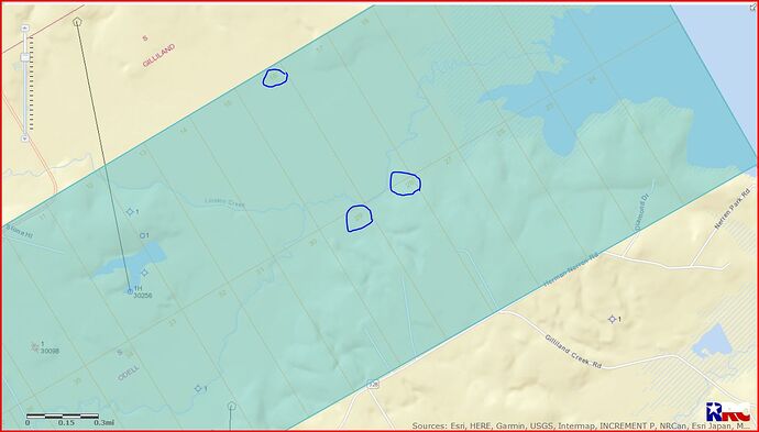
GIS map of Angelina County A-494/blocks 16, 28 and 29.
Clint Liles
Sandra,
Oops…here is the GIS map of Angelina County Abstract 494/Blocks 16, 28 and 29:
DOUBLE LEFT CLICK ON MAP TO ENLARGE
Clint Liles
Sorry to hear that especially when online searches for permit information comes with a price. The forum is a good source of information and greatly appreciated.
Not sure what “price” you are talking about on permits? Searches for new permits or any other information that has been filed with the Railroad Commission is free on their website.
Hi Dusty, I was speaking of websites other than the RRC that require “memberships” or such to get information. If you have a link to get me on the right page on the RRC site for drilling information, that would be very helpful. Thanks for your email.
Here is the link I use to see drilling permits http://webapps.rrc.state.tx.us/DP/initializePublicQueryAction.do
If you aren’t familiar with using RRC’s site, at the right side of the page that comes up you’ll see “County”. Scroll down that list and click Angelina, then go to the bottom of the page and at the right side fill in the blank for “Submitted Date” to search the time period you want to see. You have to use four digits for the year there…such as Begin 1/1/2019 End 2/2/2019. Then click “Submit” at the bottom left of the page and all the new permits that were filed in Angelina Co. during that time period should pull up for you. On the page that pulls up you can open any of the the drill permits you want to see by clicking the “Lease Name” that is in blue.
I’m always interested in seeing permits as soon as they are filed so I always search by “Submitted Date” but on that first page you can also fill in the “Approved Date” blanks if you only want to see the permits that have already completed the RRC approval process. If you are only interested in the permits filed by one operator there are blanks were you can put their name, or can enter a lease name if you are only trying to find new permits filed in one lease.
Hope this helps. If you can’t get it to work come back with questions. You’re right that it won’t show progress on drilling like the paid services can but it’s free and is fine for following permit activity.
This absolute helps! If I have any trouble, I send an email. Thanks so much for taking time to educate me on this topic. sknight
Glad it helped.
Using the submitted date will always let you see the newest filings but until a permit has been approved you won’t be able to pull it up and see the location on RRC’s map. If you click on a new permit and want to see the location go to the bottom of the second page where it lists attachments and click the “Plat”. It will open the survey plat the operator filed showing the location.
I tried the link you provided, but was unable to connect. Each time I try, it takes me to Texas RRC - RRC Online General Maintenance page. If you’re in the oil/gas profession, you may have “permissions” through a source I don’t have.
