Looking at the Section 7 in Google Earth, I see an oil well in the lower SW quarter of that section. I thought the oil royalty included the entire 640 acre of Section 7, so I wonder why we aren't we aren't already getting paid royalty?
M Barnes said:
The likelihood of drilling in 7-1N-4W is very good. It is along the condensate/oil line of the Woodford and drilling is moving that direction. They are already drilling two sections to the south, so I expect they will fill in the gap when they get it leased up enough. Marathon is also leasing that section.
Last December I counted 64 leases less than 3 years old in 7 1N6W. It's crude research, as I don't have any way of knowing the acerage involved, but just by counting the numbers there has been a whole lot of money being thrown into leases in that area. One CLR report I saw said they were leasing in "stealth mode". All I know is that there have been around 1000 leases, mostly by Bearcat, presumably on behalf of CLR in a 6 to 7 mile radius of Section 15, where I have interests. Yet, on all of the maps presented at the Quarterlys most all the formations are shown to be well east of there. So my question for Martha is, how proprietary is geologic data? Since the corporations are funding it, wouldn't it make sense for them to also lie about it in seeking competitive advangtage? Or is the science more open than that? Given the 18 rigs CLR has in Southern Oklahoma this year, there's no way they're gonna HBP a large fraction of it. Are the minerals here so valuable as to compel the holding of leases in order to prevent the competition from doing so?
Kenneth,
I just ran a lease check and there are at least 84 leases in 7 1N6W in the past 36 months with the most recent March 28, 2014, so I think there may be more than that and the new ones aren't posted yet. About 60 of them were in 2012, so they expire in 2015. They have a few more months to get going….
To answer your questions, seismic data is super proprietary! The interpretations from that are also proprietary. Basic geologic knowledge in the area can be gleaned by a good geologist by looking at old wells, outcrops, old scientific papers, etc., so not so proprietary if you have access to the public data. But joining the geologic knowledge with the seismic geophysical knowledge is golden (or sticky black oil) in this case. The knowledge is well guarded for competitive advantage.
Given that the horizontal wells have had tremendous success over the last couple of years, yes, the minerals here are vastly valuable and they will hold the leases if they can. They may have to re-lease if they run out of time. That is starting to happen a lot, so folks will usually get better money the next time. Newfield, Continental, Marathon, etc. are usually drilling one well in a section to hold it by HBP and then coming back later to infill drill. If you look at the drilling and spacing notices appendix of owners, you will see that there are lots of shared interests, so CLR doesn't hold a section all by itself.
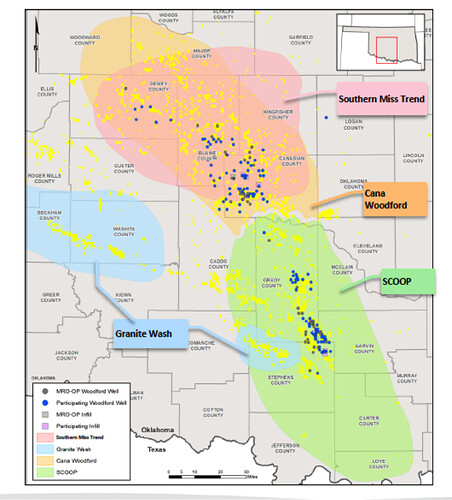
For 7-1N-6W, it is on the edge of the SCOOP Woodford play, and at the edge of the Granite Wash play, so we will see what develops there. I am attaching a picture from a Marathon presentation. I think there is a third play here that will show up in about a year, so I will wait until I have confirmation for that one .
Thank you M Barnes! Maybe it's that elusive "third play" that is responsible for all the leasing?
