Hi Dusty, I haven’t been on the site in awhile, but was checking to see if had any additional information on the Fuchs/Mitchell on Boundary School Road.
Hi Wes
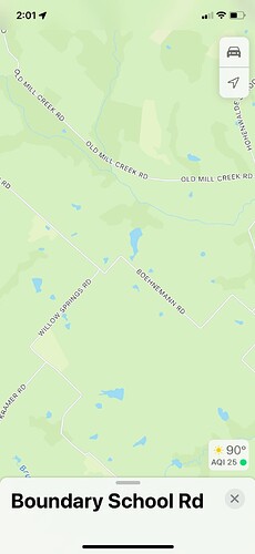
Based on what’s shown in RRC’s records all four wells Geosouthern had permits to drill from that big pad on Boundary School Road were never really drilled, just spudded using a portable rig. The records indicate three of them (Fuchs, Mitchell and Garlin) were spudded and had surface casing set to 1200’ but the big rig was never brought in to drill to the programmed depth. The records on the Fuchs and the Garlin show they were plugged as “dry holes” in January, 2021. Dry hole is probably the only designation they can use, but seems accurate to say those were cancelled permits were the surface casing got plugged. Apparently the fourth well, called the Dallmeyer, was never spudded.
On the Mitchell well, maybe it was plugged and GS never got around to reporting it. It is carried on RRC as a “shut-in producer” but the records say it was only drilled to 1239’.
RRC had automatically extended the term of all those permits a couple years, I assume due to Covid, but they finally expired on 12/31/20. Like mentioned in earlier comments, the term of the leases in those four units should have expired a couple of years ago. For anyone who had a lease there and didn’t have a lease amendment worked out by GS extending their lease term, it might be logical to request a release from them confirmed it has expired and get that recorded in Washington County Deed Records so landmen will know your acreage is open for lease. The wells completed on that side of 290 have mainly been dry gas but with the big increase in natural gas prices the economics on that type well have definitely improved.
Hi Dusty,
Thanks for the information. After reading reading your email, I reached out to the land man who contacted us for the lease. He said that Geosouthern had concerns that the lease was on the wrong side of a fault and didn’t feel that it was worthwhile to complete the well. However, with the uptick in gas/oil prices, I’m hoping that they take a gamble.
WP
That’s interesting. I didn’t realize there was a fault in that area.
Geosouthern had formed another unit a little north of the Fuchs that they never drilled on. Maybe higher natural gas prices will bring them back to that area. It sounds like Magnolia may also start doing some leasing rather than just added wells in existing units.
No recent leases recorded or new permits in that area.
Three years ago Geosouthern completed two wells just north and two to the south of that area that each have already made 3-5 BCF of gas but no condensate. They permitted another one that would have terminated just west of that area but when the market fell during Covid didn’t drill it.
If natural gas stays strong there should be more drilling there, but with the acreage Geosouthern already controls in those four big units they could be the only operator with the potential to do more leasing in that area.
Dusty1
Thanks for the info! In short…You called it right. Is there a way to have a private conversation with you on this site? I’m not on here much and have been unable to find one. There’s a few things I’d like to share with you, but wish to do so privately. Thanks.
Hi LGH
I noticed from 290 that a rig was up in that general area you had mentioned last year but hadn’t pinned down exactly where.
I’d definitely like to share information but unfortunately the forum no longer has any sort of direct messaging and in other spots the head man has said posting your email address is a violation of their terms of service and will be eliminated.
Maybe we’ll run into each other at the Short Stop or JW’s.
Trying to get some information on the Geosouthern Jimenez well. Alot of activity and the past few weeks after nothing since last fall.
Jimenez 1H completion report… http://webapps.rrc.texas.gov/CMPL/viewPdfReportFormAction.do?method=cmplG1FormPdf&packetSummaryId=216158
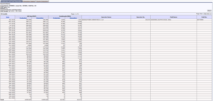
Production data on Jimenez 1H/Lease # 287869:
CLICK ON DOCUMENT TO ENLARGEHowdy1
It looks like GeoSouthern had the Jimenez 1H shut-in since sometime last August while they where in the process of fracking the four most recent wells they drilled in that area. They apparently shut-in the original Boeker well about that same time. Shutting in nearby production to protect existing laterals is pretty common when big frack jobs are done. For some reason the work on those last four wells took longer than usual but appears to finally be finished.
If you’ve seen a lot of recent activity at the Jimenez drill site off 1697 it might relate to work that was needed to bringing that original well back online. If GS put the Jiminez back in production in January then volumes should start showing up again on RRC’s reports and in royalty statements by March or April.
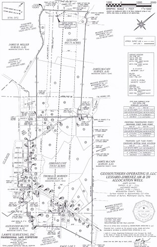
If you are in that original Jimenez unit you probably know about the two allocation wells that GeoSouthern recently completed that involved parts of the Jimenez and Lessard Units . In case you haven’t seen it, below is the unit plat showing the path of the laterals for the new Lessard-Jimenez AW-A and B in relationship to the horizontal leg of the original pooled Jimenez well.
Will the numbers ever go back up to where they were at the beginning?
tzwahr
If you are talking about the production numbers for the Jimenez 1H that Howdy1 had ask about, I’m guessing it will get back in neighborhood it was producing last June and July. Obviously that depends on my guess about GeoSouthern purposely shutting it in last August and not opening it up again until last month being right.
The production level for the Jiminez definitely won’t get back to the levels it was producing when production stated in 2019, but unless the horizontal legs of the new wells GS just completed north and south of it impact its production (which they shouldn’t) or GS has problems getting it back in production after the shut-in, then within a couple of months I don’t see why the volumes shouldn’t get back on the decline curve the well was following before the shut-in. Lot of “ifs”.
What GS reports to RRC for January and February from all the wells in that area, new and old, will be interesting to see.
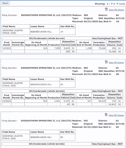
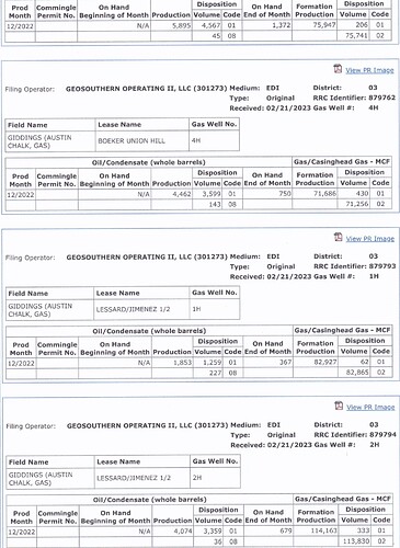
Below are the initial production numbers Geosouthern reported to RRC on the six allocation wells they recently completed around Burton.
These volumes are reported as their December production but there is no way to tell at what point that month each well came online. Based on what the first wells in that area initially made these numbers may only cover a couple of weeks of production. It also took 4-5 months before those earlier wells hit their peak levels.
Based on the December numbers reported for the original Jimenez and Boeker wells it looks like GS put them back in production sometime in December but we may have to wait until the reports are filed covering their production in January and February before we’ll be seeing normalized levels.
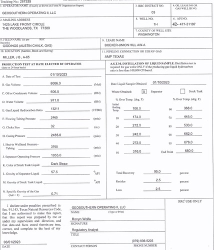
Geosouthern filed the completion report today for their Boeker-Union Hill AW-A well (also referred to as the 1H). The test results below indicate the numbers on the December report I posted yesterday had only covered production during a half month or less.
Dusty1, Going by these numbers on the Jimenez wells, do they seem to be producing at a good rate? What do we look for to know if it’s a good producer or not?
You can’t judge much from those first month production numbers because they don’t show how many days of that first month the well was producing, or if was choked back during that time.
In the initial phases of production much of the water and other fluids pumped into the well during fracking is recovered along with the gas and condensate that is being produced. It can often take a couple of months for that flowback of other fluids to dissipate and the well to reach it’s stabilized potential.
Geosouthern just filed completion reports on two of the Boeker-Union Hill wells and will probably be filing those other four soon. The completion tests give a better idea of the well’s capabilities.
If you were in the original Jiminez Unit you probably understand Geosouthern drilled all six of these new wells, including the Lessard/Jiminez AW-A and B, as Allocation Wells rather than making them part of those original pooled units. The royalties on each of those allocation wells, rather than being based on mineral acreage in the pooled units, will be allocated based on the percentage of the horizontal producing legs of those new wells, if any, that was actually drilled through the boundaries of a mineral owner’s interest.
The completion tests for the six allocation wells Geosouthern recently completed near Burton are now up on RRC’s site. Below is a link to a summary of their 24 hour test numbers. The levels they tested at could turn out to be higher, or lower, than where GS starts producing them, but these numbers all look strong for Austin Chalk wells.
The two Lessard-Jiminez wells made by far the most gas, and the Boeker-Union Hill AW-A made the most condensate.
The columns on the left are the flowing and shut-in pressures GS reported. The reports show all of the wells were tested on a 32 choke except the L-J AW-A that was on a 30.
Washington County - Geosouthern - Burton Area AW Completion Tests.pdf (67.2 KB)
Hi Dusty, Thank you for all your excellent information. It’s very hard for a novice in these matters to find much less understand all this information but you provide the information and the insight. I’m wondering if you know anything about another GeoSouthern lease in Burton off 390 and about Quail Run Road. The lease name is HAP-Neinast and the approval number is #477-31248. The approval to drill was given in 12/22. We are part of this pool but have not seen much activity where we believe the drilling might take place. Any insight you have would be greatly appreciated! Robin
My guess, and it’s only that, is Geosouthern will drill the HAP-Neinast when they finish the Tate-Dahmann wells they are currently drilling a little further north on 390. They got permits to drill three wells there that were approved in November, just before your’s, so it may be several weeks before those are finished.
If you want to keep track of that rig, you can see it if take Beaver Road off 390 (headed toward the lake). After the first 90 degree turn stay straight where Beaver becomes Haack Road. You’ll see the rig on the right when you get to the first curve in Haack.
The HAP-Neinast drill site isn’t visible from 390 but based on the new entry road they’ve built and the sign by the gate I expect the pad ready. If you haven’t seen that entry it’s on the west (lake) side of 390 just north of FM 2697.
