Has anyone been contacted about leasing in McKenzie County recently? It is for: Township 146 North, Range 99 West, County, 5th P.M. Section 35: N2. Thank you
Looks like leases have been filed recently in Section 26 and 36 next to you. Most are 1/6th.
Rockport Energy has a rig drilling the Merritt 18-19-30 two miles to the east of you in 146N-98W. Target is Middle Bakken
I have been contacted about 146-98-##. There has been some drilling activity recently - if you go to the ND site and type in “Ranch Creek”, you will see what I mean.
Just received offer for 146, 98 10 for 3/16ths and $850 per acre. Also 147, 99, 26 for 20% and 1350 acre. These seem low to me. Any other recents out there? Thanks to all!
which section are you in Rick
Like it says R146N, t98W sec 10 and r147N, t99W, sec 26
Type it in where? In the GIS map?
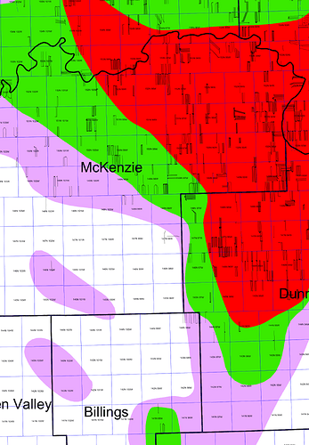
It is very interesting that you received an ok offer in section 146 98 and 147 99. The Tier Map says it is just outside Tier 3. It used to be much lower offers.
I thought so too. We have owned these since the 20s and had leases but no wells.
Could I ask where the map came from? I’d like to see more.
That offer seems totally in line with the “well jeez this isn’t great but there is oil here and no wells and maybe these things can make 350kbo each and we got nowhere else to go” outlook. Makes total sense to me.
This is where folks like Rockport have to YOLO it up on places to drill.
From the ND website, it looks like Rockport Energy Solutions has drilled the Camden 10-3-3H, spudded on 6/28/24, with sections 3 and 10 of 146 98 as its spacing unit. The well is on confidential status, so no status update is given. ND well file number is 40731. I’m surprised you haven’t been leased already.
All starting to make semse. Thanks very much to all.
That is very interesting. I have never seen that before.
Thanks much for the map!
I got an offer to purchase 147 North, Range 99 West, McKenzie County, 5th P.M. Section 20: NW, NE, SE, SW. Heard there’s some activity in the area. Already have it leased.
Offers to buy frequently come before drilling, so someone may know something. If you have no need to sell, then just sit back and wait. The lease also implies potential drilling. There are permits in the townships around you and you have horizontal wells nearby, so you section may be of interest for a horizontal or more than one.
This is helpful. How do I go about finding out where the drilling is taking place or there are permits happening around me? I’ve also hired Diamond Resources to do an appraisal.
https://www.dmr.nd.gov/oilgas/ You can watch for free or you can pay about $50 per year and more indepth data.

