Good Day to Fellow Mineral Owners and my Fellow Texans,
Would Greatly Appreciate any assistance with news on activity on the above area described on my tax statements as RRC Tract 182,Block 34 - 80 acres total. I am a bit limited in my ability to access Oil & Gas Permits information for this area in Ward Co. I've tried several times to view Clint Liles' postings, but have been unsuccessful. I have noticed that my particular 80 acre location seems to have had activity quite near by reading other postings. I am still trying to get up to speed on this new world. Unfortunately, a few fires have prevented my education in a more timely fashion.
I would be most grateful for any help. Also would appreciate any recommendations on an honest Oil & Gas Attorney, since I am far away and don't have any local contacts. Personal experience with an O&G atty meant a great deal when I lived in Texas. Reputation Matters.
Thanks Much for the Kindness of a Reply,
Anne Marie
Anne Marie:
I have used Dentons out of the Dallas/Ft. Worth area as my oil and gas attorneys and they have been superb. Check out their web site. If interested, I can provide a couple of names there. Just let me know and I'll be happy to provide their names and email addresses.
John A.
Anne Marie,
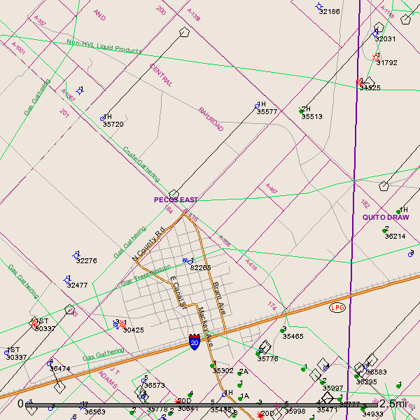
after checking the GIS Map I see where there are 3 different Block 34, Section 182 in Ward County.
A-416 H&TC RR CO 34 182 BRIGGS, L W
A-467 H&TC RR CO 34 182 TRACKLER, J A
A-358 H&TC RR CO 34 182 DAGGETT, W M
If you possibly could check to see which Abstract # is yours:
A-416, A-467, or A-358
Also Anne Marie I suggest you get in touch with Wade Caldwell in San Antonio. He is a very knowledgeable oil and gas attorney and is working some leases in the Ward County area at this time. He is also a member of this Ward County Group.
http://www.beclaw.com/
Clint Liles
Anne Marie,
After further examination I see where the 3 Abstract #'s make up the 640 acre Section 182. Although I see on the GIS Map where in Section 182 there are 2 A-416. This(Section 182) looks to me like 1mile square which would be 640 acres.
A-416 to the right on the GIS map is possibly 320 acres.
A-467 is possibly 80 acres.
A-358 is possibly 80 acres.
And A-416 to the left is possibly 160 acres.
Duh. Looks like a foul up on someones part. I've also seen on these maps A-? so who knows.
GIS Map of Ward County Section 182/Block 34:
Clint Liles
Anne Marie-
Jetta has been leasing there and in adjacent sections. Since it is next to Barstow, there are a lot of owners. Very active area.
Anne Marie,
My family also owns minerals in Section 182. We are leased to Anadarko and Jetta. I don’t believe either company has permitted a well.
