First off, I know “Survey” may sound wrong, but that’s the official legal description of this property…at least in the records I received from lawyers. (Does “Survey” mean the same thing as “Section” in Texas? I’m more familiar with Oklahoma terminology.) Anywho, I leased property with the full legal of SW/4 & W/2 SE4 & W/2 NW/4 Survey 16, Block 3.5 to Silver Creek Oil & Gas in 2014, then they re-leased it in 2017, for another three years, so that lease ended in 2020. Haven’t received any division order and wondered if anyone knows about production in this property. Thank you in advance for any help you can provide.
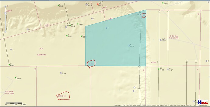
Hello Angela…it’s been awhile… I don’t find any production at all in Section 16. In 2014 Silver Creek Oil and Gas had an approved permit to drill a horizontal well(API 461-39783) in Section 6 and would have ended in Section 16 but that well was never drilled. After checking the surrounding area I find no activity and some of the wells that have been drilled in the past are very poor productive wells. (And you can scratch through the word Survey and put in Section instead.)
Upton County Section 16/Block 3.5/A-987:
CLICK ON MAP TO ENLARGEHi Clint, thank you so much for your response. Hope you’re doing well! This lease was the first (and only) time I negotiated for 1/4 royalty, so it makes sense it never even got drilled, haha. Oh well, maybe another company will come along and have better luck. By the way, I bet there are some fascinating stories about why drilling never happens in some cases. My records show Silver Creek paid a pretty good bonus, and they paid it twice. I figured a good bonus means someone thinks there’s a good chance of hitting oil/gas. Apparently it doesn’t always work that way.
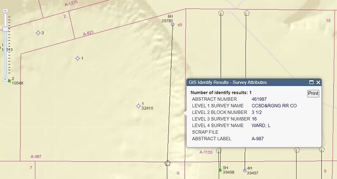
Below is the current Railroad Commission map of the area you described. What was called Survey 16 is actually Section 16. It is also known as the L. Ward Survey, Abstract 987.
According to RRC’s records, in September, 2014 Silver Creek got a permit approved to drill a horizontal well they designated as the Milkyway 16 #6H. The drilling unit was supposed to include all of Section 16. But the well was never drilled so the permit expired in 2017. The map is still showing the location they proposed running parallel to the east boundary of Section 16. At the same time Silver Creek permitted another well that was never drilled that would have extended south through Section 6.
The map shows a horizontal well to the east in Section 15 that Apache drilled in 2015 but that showed very little production. Apache cancelled the other wells they had permitted in that section, and it could have been the reason Silver Creek decided not to drill what they had permitted in Section 16 and 6.
Dusty:
Thank you for your detailed response! I remember you helping me out once before with a question I posted…you’re a gem!
It’s too bad this area didn’t get drilled, but I understand why it wasn’t…not worth the expense when there’s little production in surrounding areas.
This topic was automatically closed after 90 days. New replies are no longer allowed.

