My Mom inherited mineral rights & received checks for many years. They stopped several years back & I am wanting to find out why or what happened. The mineral rights are in Mitchell and Scurry Counties of Texas. How can I research this further?
Can U give the API # of the well(s) in each county or the exact name of the wells…how about the section, block and/or abstract #…or the lease #
The most recent information I can find shows Sections 26,27,31,32 and 36 Block Y, T&PRR Co Survey, save and except 40 acre proration unit undder and around the Enterprise #1 Well.
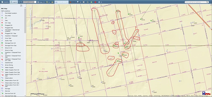
This GIS map will show sections 26, 27, 31, 32 and 36/Block Y in Scurry and Mitchell Counties…well API 415-35627 shows a completion report but no production data yet. Wells # 35286 is a producing vertical well. Wells 35533, 35117, 35497, 35627 and 35886 are Horizontal oil/gas wells…some pretty good wells here. GIS map of Sections 26, 27, 31, 32 and 36/Block Y of Scurry and Mitchell Counties.
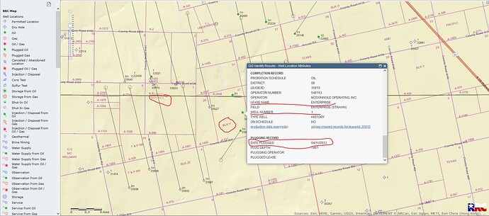
CLICK ON MAP TO ENLARGEThe information I get from the RR Commission GIS map is that the Enterprise #1 was plugged on April 11, 2013/API 335-34057/Lease # 35915/Mitchell County Section 27…
CLICK ON MAP TO ENLARGEHow do I go about finding out what happened to my Mom’s payments? She hasn’t moved or changed her name so not sure what happened.
The operator/producer for well 335-33286/lease # 54935/vertial well.. is McDonnold Operating, Inc…I would call the operator contact # and go from there.

The operator for the other wells in Sections 26, 27, 31, 32 and 36 is Three Span Oil and Gas, Inc. Well 35886/lease #54936///well 35117/lease #354937///well 35533/lease #56277///well 35497/lease #56277///well 35626/NO LEASE NUMBER YET.
Thank you soooo much! I will update you when I get information!
I am under one of the many wells by Three Span in this area (Scurry). This has been a very interesting development by them and Carr Resources. They are still trying to define the potential.
My mom was notified of mineral rights. Her sister received a check, but my mom never did. I was contacted by AMCO Holdings about selling with my name and my mom OBO. I don’t have any documentation and my mom doesn’t understand fully and gets confused on business items at times. How can I find more information?
It is always helpful to post the County/State where the property is located. Once you post this, people can offer specific information to help you through this process.
Parcels 3-14-27/28 Doddridge County, West Virginia. I found some lease renewals, but that’s about it.
I have not had much experience in WV, but here is a little information that I have been able to glean from O&G development maps. Horizontal well development in the county looks to be primarily by two companies, EQT and Antero. My plat maps are not specific enough to locate your particular property, but it looks like EQT is the area of your property. Your county tax assessor may some information/maps that you can view to get better information. If you mother and her sister are owners in the same property, then your mother should have received checks also. Try contacting the company that sent your aunt checks. It would be good to have a copy of one of her checks for reference. Good luck.
This is only a partial answer. You can view the county clerks index by doing a search of IDX for Doddridge county. To find the website, just do a search for Doddridge county IDX and it will come up as the first or second search. You can then put your mother’s name in the search to see if it has been sold for a tax sale or something else.
This topic was automatically closed after 90 days. New replies are no longer allowed.


