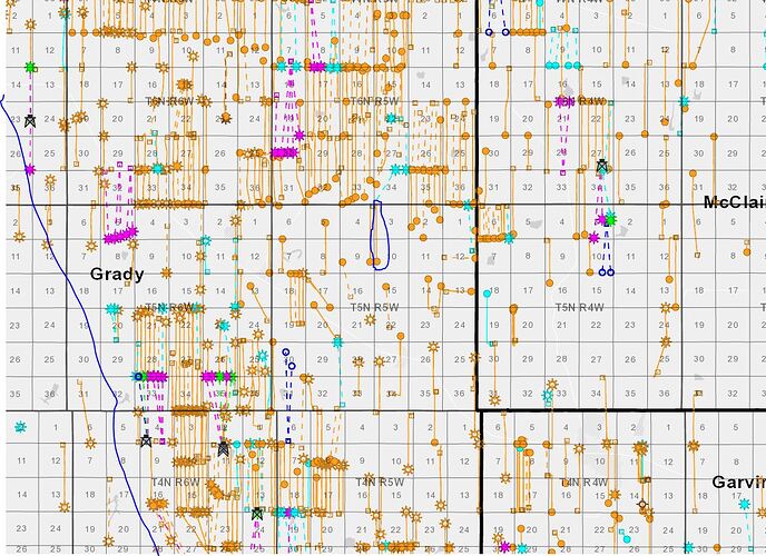
10-5-5 Grady County. I have part interest in the Black Mesa, which is a horizontal well that has been producing since 2/2020. I am 78 and plan to leave my mineral rights to my granddaughter who is currently a minor. This well was drilled to the Woodford. There is also an old shut-in vertical well. Do these mineral rights have much of a future value outside of the current producing well? What are the future possibilities of where they could drill a well once the current well is expended? Do they wait until the current well is exhausted until considering drilling another well? I know some of these questions may not have an answer but would like to hear your thoughts if you would reply. Thanks.
Activity can be dependent on a multitude of factors. Sometimes Operators drill a well and then leave for awhile because they have other acreage they need to drill to hold (i.e cheaper to drill a well to hold acreage then to release and pay out another round of lease bonuses). The area you are in is interesting because there are multiple rigs running SW and E meaning companies are still in the area drilling. There are pads with up to 8 wells on them just meaning that you do have the “potential” to have additional wells drilled the question is when. As you can imagine, having another 5-6 wells drilled will vastly increase the size of your revenue check.
Camino Natural Resources who is your Operator, is private equity backed (NGP). Over 60% of new rigs added in 2021 have been from private operators looking to increase their production to sell (potentially) to a larger Operator. Again, all this means is that you may see an increase in activity since your Operator is private and a core holding of a PE firm that will need to sell at some point.
Thank you for your reply. That is a great map. Where did you get it?
I’ll try to not violate the “marketing” clause of the forum (haha). There are a ton of services out there to create these maps either from the state regulatory agency, etc. The map I attached is from a paid provider, Enverus. There is a free service out there from Enverus called MineraliQ which provides a similar map.
One additional comment on the map itself is that most owners have the issue of “potential”. Does my acreage have the potential for additional wells to be drilled. We most commonly use “offsets” to describe potential. For example, there is an 8 well pad one section over but I only have 1 well drilled which means I have the potential for 7 more to be drilled. From the quick glance I think it is fair to say that your acreage does have the potential but again, its a question of time and value is heavily dependent on time.
Is the color coding just to delineate on area from the next or is purple a newer well? I’m primarily asking to clarify sect 5-5-6, Grady….no completions reported but does that shoe 5 wells done?
Yes, sorry should have included legend.
Orange: Active producing Purple: DUC (drilled uncompleted) Blue: Drilling (rig on site GPS) Light Blue: Inactive Green: Completed
This topic was automatically closed after 90 days. New replies are no longer allowed.
