anyone know what the going rate is for cubic ft of natural gas at well head, and oil also found out the mineral rights property has 4 wells on it, one produced 1057000, gas in 2011 and 4067 i gues barrles of oil, and it varies from year to year, i have never recieved any monies from these wells, thinking of contacting kyle nuttall , i did not even know i owned 1/8 of royalties
Randall,
We brokered a deal in Wetzel, Church right before Christmas for $8,000 per acre. It was leased with Dominion and it was a large chunk of acreage. Every tract/parcel is unique so pricing is not spot on.
Becky,
$8,000.00 is great, but what were the terms you negotiated? What clauses did you insist on including? Royalties based on Net or Gross? How were liquids handled?
Truly, I and no doubt many others are curious as to hear what you were able to negotiate.
8,000 was to sell the oil and gas rights which were in a second term with Dominion at 12.5%, net.
We are working with a guy now to sell his acreage that was leased with Antero in Church District, June 2017, 5 yr primary, 5 year extension, at 18%, gross, $4,500 extension payment. We did not negotiate that lease for him.
http://www.naturalgasintel.com/data/data_products/daily?region_id=appalachia&location_id=NEACNG
This website tracts the price of Appalachian gas. Appalachian gas is selling lower than any other place in the country right now. As for the NGL they are pretty much tied to the price of a barrel of oil. The Utica Oil and NGL in Ohio have a separate market for the price...that's the only place in Appalachia I know of that the NGL and Oil have there own market spot price. If you tell me the tax map parcel number of your property I can tell you just about everything you would need to know.
map parcel is 04-24-44 and 46, wetzel county grant district any help is apreciated , thank you
Ill look at it this afternoon, this evening.
I looked at this property in Wetzel County...I cannot find a permitted Marcellus lateral crossing this property. Which well are you referencing the production numbers from 2011? EQT drilled a bunch of laterals to the west of this property, but nothing on this property. You are an heir to E.Z and Amy Horner who lived in Parkersburg. I believe they had 8 kids and one of them was a Mary C. Beha who had 7 kids...one of them Lillian M. Foutty who had 8 kids. So it looks like the 1/8th interest you are referring to is just that share that came from Lilliam M. Foutty. The affidavits and wills are all on record in Wetzel County Courthouse. It appears this property has been cut up pretty good, which is common...This property is in the center of an old oil field and families reserved the minerals when they sold the farm.
Hope this helps.
wells 4710301062, 4710302433,4710302434,4710302435 so it has all 8 of moms_lillians children on 1/8 intrest split among us ?
I think 4710301062 was drilled on the BW Peterson property to the west...Its the BW Peterson #52. The API numbers you referenced are actually 4710372433, 4710372434, and 4710372435...these are old wells. The WVGES put a 3,5 or a 7 in front of the permit number as a backlog reference for wells drilled before 1929. None of these wells are producing...THe Horner 1- 72434 didn't produce much...72435 the Horner 2 was plugged almost immediately after it was drilled...and the Horner 3 produced oil for some time I would say...but probably none in the last 75 years. Any royalties from these wells went to your ancestors. I understand the confusion...The state should have a better way to classify these old wells.
the well 4710372435, produce 1057064 in gas in 2011, in oil 4067, link is http://www.wvgs.wvnet.edu/oginfo/pipeline/pipeline2.asp?txtsearchapi=470332166, this was research done by antero,
According to the affidavits on file...yes.
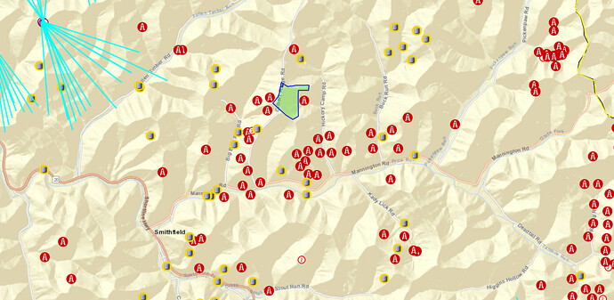
I believe this is a screenshot of the tracts in questions. The red icons are shallow wells that are plugged. Yellow are producing but this data is a tad dated. The purple with the sticks are producing horizontal wells. Not much going on in the immediate area. It looks like Robert has a good grasp on the title. Fractional acreage looks small.
I attached the plats for 4710302433. 4710302434 and 4710302435.
I attached the plats for 4710302433. 4710302434 and 4710302435.
I attached the plats for 4710302433. 4710302434 and 4710302435.
I have the plats for those three wells but the site wont let me upload them. Ill see if I can screenshot them.
i cannot find any information on the api numbers you have listed, and as for plat maps can you send them to my email, fouttyr@aol.com, thank you
do you have the plat info for the horner property/wells, and if so can you send them to me as well, thanks
My grandmother, Lillian Horner Parish, was one of the inheritors of Lillian Horner Foutty’s share of the E. Z. and Amy Horner property. I received and offer for purchase of my interest inherited from my grandmother for $5500/acre with no retention of mineral rights. Since I live in Colorado I am unfamiliar with the purchase and minerals retention standards in Wetzel County I would be grateful for any guidance in this area. The parcels in question are 02-11-54, 02-15-18 and 02-15-16. My grandfather, Grover C. Parish, was a wildcatter and driller who moved to Texas and was a part of the oil boom in the Lower Permian Basin in the 20’s and 30’s, but I am a consultant in the renewable energy industry…but a firm believer that energy security involves all forms of energy.
