My property at section8, block 53, Culberson county. I received the offer letter from the bank asking to buy surface of my land. Does it mean anything about oil or mineral under my land, and how do I find out I own the mineral or not. I need any idea from anyone. Thank you very much.
Moved to Culberson County.
Hello John, After checking the GIS(Geographic Information Survey) map I find several Section 8 but no Block 53 for Culberson County. Check your legal description again and post the ‘complete’ legal description.
Clint Liles
Thank you very much Clint, I will check my WD again
Yes, theWD said at a point 2640.00 feet N 00’ 00’’ W from the southeast corner of section8, block 53, and northeast corner of lot 5
And AB 4583 BLK53 SEC8 PSL
John I found the location. Abstract 4583 did not work.
There are some good oil/gas wells and some very good gas wells producing from the Wolfcamp formation in this area.
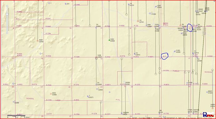
There is a shut-in gas well(API 109-33213) that starts in Section 17 and ends in Section 8. This link is to the approved permit for that shut in gas well…
There is also a cancelled/abandoned location in Section 8((API 109-32924).
APR Operating seems to be the major operator in this area but at this time I don’t see any activity in this area.
This link is to production data on gas well API 109-32988 next door to the North of Section 8/ this well has been producing since April 2018:
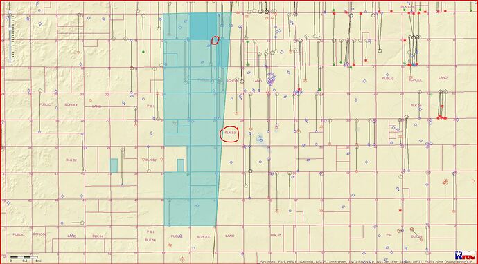
GIS map of Culberson County Section 8/Block 53 and surrounding area:
LEFT CLICK ON MAP TO ENLARGE
GIS Map of Block 53:
LEFT CLICK ON MAP TO ENLARGE
Clint Liles
Thank you very much. I will contact you later
I called the county clerk to ask them about my mineral rights, they referred me to call the appraisal department. But, both department said I have to find out by the warrantee deed I have. But the deed is very confusing about the mineral rights. Can you help me figure this out? Thank you.
How do I know what theses company doing anything in my property there like drilling or put the ROD lines over my property. Or I have to go there to check, cause I have couple 𝘖𝘧𝘧𝘦𝘳 from bank to buy 100% surface interest of my property
Hello Clint! I bought a property back in 2005. I have the Warranty Deed which was recorded by Culberson County at that time. Besides the Warranty Deed, I was given by the seller map documentation to show the property’s location. I would like to know how do I find out about the ownership of Mineral Rights / Oil & Gas Rights among other similar things.
Thank you very much, John.
I would go to/or call the Culberson County Clerks Office and possibly they can help you. You may have to hire an attorney to help you.
http://www.co.culberson.tx.us/page/culberson.County.Clerk
Clint Liles
Hello Clint! I called them before holiday, they said call land appraisal, I called appraisal , then appraisal said they don’t know.
You possibly need the help of a landman or oil/gas attorney. I suggest you get in touch with Wade Caldwell/Oil & Gas Attorney/San Antonio, Texas. He is a member of this Forum and is well liked by those that have used his services.
[Wade Caldwell gcaldwell@ceflegalsa.com](http://Wade Caldwell gcaldwell@ceflegalsa.com)
210)228-3617
Clint Liles
Thank you Clint, I need to call a land man tomorrow I see Clayton Williams is a land man there
Thank you Clint, oh I did not see the link below your post. Yes, I will call Wade tomorrow Thanks again
Hello Wade! My name is John. Clint gave me your number: (210)228-3617 To help me to find out the ownership of my property in Culberson county. Can I call you ? Thank you
Yes. In this afternoon.
Johntran, Texas General Land Office owns the mineral estate under your land. The estates were severed many many years ago and State reserved them.
Mean any landowner own surface top only?

