How to find out who is drilling where (HORIZONTALLY)?

Here’s what I’m trying to figure out: Given the sections that we own, who are the operators either ON it or UNDER it, or RUNNING THROUGH it (or the drilling units that they belong to) that we should be receiving royalty from, given the state laws ?

[ocdimage.emnrd.state.nm.us] is helpful, but it only shows surface location wells, not the wells that would be drilling horizontally through my father’s land OR the drilling units that would be connected with my father’s property, so it doesn’t give the complete information I’m looking for.

My question to the forum: How do I track down this information?

Since the royalty checks that my father receives aren’t related to leases that he personally owns, it seems like it’s really hard to get any information.

From what I can tell he’s getting payments for production that is happening from other leases, but 1) because they drill horizontally THROUGH his land, he gets a payment on that production or 2) because his land is part of a drilling unit that contains a section that is being drilled on he gets payments.

I would think that somebody in New Mexico would be keeping track of who is drilling where, but it seems to be only lease based, not section based. So if I say “it’s section X” nobody can tell me who is drilling there (except surface wells). So if you don’t have a specific lease to look up, they can’t help you. Here’s what I did so far:

I called the Eddy county assessor, the Eddy county clerks office, and the state land office (oil and gas dept).

The state land office looked at my areas, and said "since none of the leases on this land are owned by us, and they are private leases, we don’t keep track of them and therefore have no information. call the county clerk office, they should know about private leases and land. "

The county clerks/assessor’s office said "we only keep track of specific leases, so if you have a specific lease I can look it up for you. But we don’t keep track of drillers, we don’t keep track of operators. I can’t tell you who would be drilling in your section (or under it). Somebody is probably keeping track of that information, but I don’t know who, and it’s not us. "

Is there any other way to get this information?

Thank you again!

For reference, there are 3 quarters in question, which are:

  • Quarter: NE, S:11, T:25S, R: 28E SENE (Carlsbad 88220)
  • Quarter: NW, S:12, T:25S, R: 28E SWNW (Carlsbad 88220)
  • Quarter: SW, S:12, T:25S, R: 28E SWNW (Carlsbad 88220)
Use your checks as your starting point. Contact the operators that send you the check. As for the Division Order department. Ask for a copy of the well plats “as Drilled”. Ask for copies of the Division Orders that go with the wells. Have your dad’s owner number ready. Have your sections ready. I am not familiar with New Mexico tax laws, but you may have to pay property taxes on the production, so you need to track that down in the county. You don’t want to lose the mineral rights from not paying taxes on time. Many states have them due this time of year. Also ask them requirements they have for transferring the title to the heirs.

Using only the NM OCD website. I looked at your NE Quarter Section 11, T25S R28E location.

You have acreage in the NE quarter there and using the OCD Map see nothing to the south of your area so went north and see 2 wells operated by Mewbourne.

HOSS 2 11 W2BO FEDERAL COM #001H which is drilled in the Wolfcamp Zone. It has produced 396,543 lifetime barrels of oil as of feb 2020. Started producing in Nov 2017 thru present day. This is a 2 mile Horizontal starting in section 2 and running through section 11. The pool is 640 acres and encompasses the east half of sections 2 and 11.

HOSS 2 11 B2BO FEDERAL COM #002H this is a Bonespring well also running form section 2 thru section 11 but is showing a 320 acre pool which represents that is only includes a 40 acre wide strip in the western half of the eastern half of those sections. Very strange pooling in that it does not match the wolfcamp well. This has produced 336,571 barrels from 2017 to the present. You might not have the same percentage of royalties on this as on the wolfcamp well.

Your Checks should show the name of the wells in the breakdown.

Your fathers records should have had a division order from Mewbourne which showed the percentage of ownership attributed to each well.

The well files section for those wells will show what the pooling is reported as and the plat of the well as it maps to the 40 acre plots in the section. You could also trace back to the original pooling orders to find the pooling approved by the state.

Your father should have started receiving checks on those two wells in about 2018 but paid for the 2017 production through the present day.

1 Like

The pooling for the wells in Section 11. Is as I posted in a different post and that is the way Mewbourne applied for them. You can use the case files and there will be a directory that will have other documents such as the Pooling hearing which will have testimony from the company geologists and engineers as they were seeking the pooling order.

You will have different percentages for the two different wells that may include your ownership rights. One encompasses everything you own in section 11 and the other may only encompass a portion due to it being half of the half section width.

"STATEMENT OF THE CASE APPLICANT Mewboume Oil Company seeks an order approving a 640 acre non standard gas spacing and proration unit (project area) m the Wolfcamp formation comprised of the E/2 of Section 2 and the E/2 of Section 11 Township 25 South Range 28 East, NMPM Applicant further seeks the pooling of all mineral interests in the Wolfcamp formation underlying the non standard unit The unit will be dedicated to the Hoss 2/11 W2BO Fed Com Well No 1H a horizontal well with a surface location 185 feet from the north line and 1700 feet from the east line of Section 2, and a terminus 330 feet from the south line and 1650 feet from the east line of Section 11 "

" STATEMENT OF THE CASE APPLICANT Mewboume Oil Company seeks an order approving a 320 acre non standard oil spacing and proration unit (project area) in the Bone Spring formation comprised of the W/2E/2 of Section 2 and the W/2E/2 of Section 11 Township 25 South Range 28 East NMPM Applicant further seeks the pooling of all mineral interests in the Bone Spring formation underlying the non standard unit The unit will be dedicated to the Hoss 2/11 B2BO Fed Com Well No 2H a horizontal well with a surface location 185 feet from the north line and 1650 feet from the east line of Section 2, and a terminus 330 feet from the south line and 1650 feet from the east line of section 11. "

1 Like

Thank you all so much for your replies. I am going through what you wrote now.

One reason I am on this mission to find out more, is because it seems like my dad wasn’t getting checks from everybody who he should have been. For example he has received no checks for anything on section 11 (from what I know). Only section 12.

This makes me think that there could be other operators that we don’t even know about who are not making proper payments. I am trying to be proactive rather than just wait and see which checks arrive. Maybe everybody is paying correctly and I can just reverse engineer what is written on the checks. But until I know myself which operators should be paying, I can’t know this for certain.

@CMC15. I don’t believe my father has ever received any royalties for section 11. He has owned this land for YEARS. Do you think this might mean that they have overlooked payment or that back payment it due?

Going to go through what you all wrote now to try to understand it better. Thanks again!

1 Like

From Your Description above for Section 11, I see the SE quarter of the NE quarter.

If he owned the land then need to verify he owned the Mineral Rights.

The only strange exception to the pooling order was that Mewbourn was not attempting to pool some Tap Rock interests which were leased from a James Monroe Cooksey III for the N/2 of NE/4 and the S/2 of NE/4 which to me indicates all of the NE Quarter. They don’t specify acreage in the lease.

Also listed for the same land maybe a different percentage was Joy Elizabeth Cooksey for the same land description. N/2 of NE/4 and S/2 of NE/4.

They also listed a lease for Tap Rock from the lessor listed as Panhandle Oil and Gas. This showed a description matching yours as : SE/4 NE/4 of Section 11 Township 25 South. Range 28 East containing 40 00 acres more or less (the “Lands”)

This seems to describe property you have interest in. The fact that they did not include Tap Rock is strange. Tap Rock did not object to the well, but only asked for time to review due to not having been provided an operating agreement.

If you recognize any of these entities or can find lease papers from your father to Tap Rock Resources you might be able to get information from them.

Thanks CMC15. I don’t fully understand what you are saying (all of this is above my head), so I will have to forward it to somebody who might have a better grasp.

In a nutshell, does this mean that there are or are not producers on section 11, from what you can tell?

thanks again

Yes, Mewbourne is producing on Section 11. They have a well drilled into the Wolfcamp Oil Zone that covers the eatsern half of section 2 and the eastern half of section 11. If you have land and mineral rights on it you should be getting paid or owed back pay.

The other well into the Bonespring zone does not include your parcel in the SE NE quarter.

Your first step is defining what land and minerals you have in Section 11. If land is owned then taxes should have been paid and this can simplifiy your search. I see that there are parcels in Section 11 SE NE Quarter owned by the Charles G Wiley Trust. There is also land on section 12 owned by the same Trust that ajoins the land on Section 11. A land man can help with that or you can go through the county records to find that out yourself.

https://www.basinlandrecords.com/creddy.html

Create a login profile and go searching with your father’s name for land records. I have seen these go back as far as the 1970s but nothing older.

Next step is contacting Mewbourne to see what happened with those royalties. If not paid out they should be held in suspense with the State of New Mexico.

This is fantastic information, thank you. I still don’t understand how you wizards are finding all of this information. You guys are good!

Quick question - Did you find out the above info via the Eddy County New Mexico Courthouse Records website? (If not, how did you find it?)

Thanks again

For that information I just went to the Eddy County Tax Assessor page , they have a GIS map and just zoomed down.

The difficult part will be on you to find the original deeds that show when the parcels were purchased and if the mineral rights were conveyed with the land in Section 11.

The Section 12 land obviously had mineral rights included since you are getting royalties on that. The only other thing you can do is look at the checks your Father received and see if any are from Mewbourne.

You are pretty much surrounded by BLM land, not sure if the land you own was purchased from them or somehow granted.

There should be an existing Division of Interest which was created before the well was drilled and the division orders sent out. That would be in Mewbourne’s records. You can contact them to see if they have it and who it lists as the mineral owner for your Section 11 parcel.

I did see an Offset Operator plot for those sections and your section 12 parcels were listed under Panhandle Royalty Company so maybe your father had a lease with them for Section 11 also.

After reading and re-reading this quite a few times I am starting to get a clearer picture of things. Thank you for your expert advice.

My father purchased the land over 50 years ago from his grandfather. So who knows about the original deed. I will have to ask my brother. Not sure who my great grandfather purchased it from.

About the following information…

…How/where did you find this out ?

When I zoom down on that assessors map, I don’t see any wells or operators listed. Do I then look up wells by UPC numbers I get from the map, in another place?

Thank you again

When you go the NM OCD website and utilize the OCD GIS application and drill down to the actual wells,

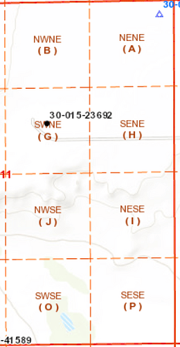
For example we will use the following well in section 11 T25S R28E.

It is shown as a black dot.

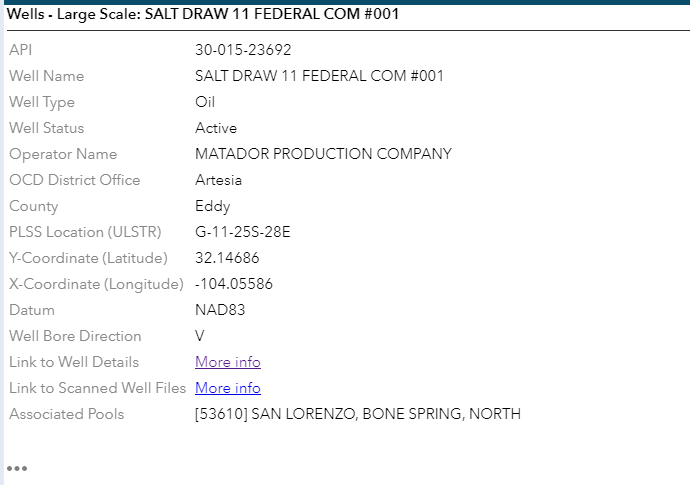
When you click on it to drill down you get the following if you choose the " > " on the pop up.

The new pop up gives some information on the well and some links to more information. You can see that it is an active well and its an oil well. You also see the type of well which is “V” for Vertical. Vertical wells are usually 40 acre pools unless they are gas and can be pooled for more acreage.

If you choose the link to " Well Details " you can zoom down to look at the production numbers. This well produced 20,647 barrels and the mineral owner shows Federal since this is on BLM land.

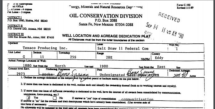
If you go back and choose the link to " Scanned Well Files " it will take you to a directory with lots of documents. This appears to have been drilled in the 80s as a Gas Well and as a 320 acre pool, then plugged back and re-completed to the " Bone Spring " in the early 1990s and changed to a 40 acre vertical.

Theoretically your father should have received royalties from the Gas well since it was a 320 acre pool, but then when it was re-designated to a 40 acre pool would not have received royalties, since it is an a different 40 acre plot than your property.

The answer to some of your questions, this directory is where I get information on the well structures as planned and drilled. Many times wells are re-worked to different oil and gas zones over time, sometime they aren’t. This is where that information would be.

Wow, thank you. That helped a lot!

Watch “How to locate your mineral rights on a map (and research oil and gas wells)” on YouTube

1 Like

This topic was automatically closed after 90 days. New replies are no longer allowed.