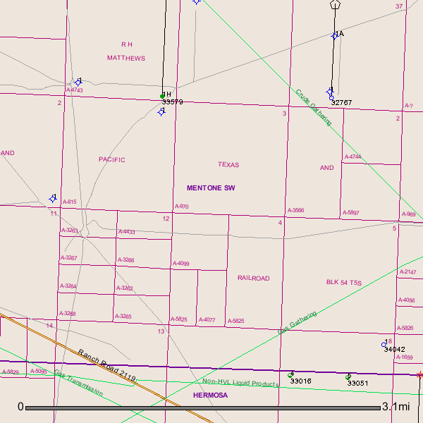
Received a new letter last week from Liberty AOG offering to buy my mineral rights for twice as much as previous offers. I'm not selling, but can someone tell me what is going on around my 20 acres -- legal description AB 4077 BLK 54-5 SEC 4 T&PS PT OF E/2 SW/4 ?
How do I get a map of activity and names of companies drilling?
http://gis2.rrc.state.tx.us/public/?
Click Accept then
Click Survey/abstract then
enter abstract number, at the top be sure to select the county, then
Enter Search
Experiment with the options i.e. select show wells etc. and zoom in and out.
June,
to the north of your A-4077 a well(API # 389-32767) was permitted by Anadarko in Feb. 2011 but I'm not sure it was ever drilled. It was permitted for 16,000' and the targeted formation was the Bone Springs. This was to be drilled in Section 37/ A-789.
Another well(API # 389 33579) north of your A-4077 was drilled by Energen Resources in Block 56/A-4743.
A good well. Completion Report shows 491 BOPD and 5,505,000 MCF gas per day.
Link to Completion Report on Well 389-33579:
http://webapps.rrc.state.tx.us/CMPL/viewPdfReportFormAction.do?method=cmplW2FormPdf&packetSummaryId=82059
GIS Map of your Reeves County A-4077/Block 54/T5S/Section 4:
Clint Liles
Thanks to everyone for the info. Clint, do you have info of the 3 wells on SW side--33016, 33051 and 34042 inSEC 8? Also, do you know anything about these companies trying to buy up the mineral rights?
Clint Liles said:
June,
to the north of your A-4077 a well(API # 389-32767) was permitted by Anadarko in Feb. 2011 but I'm not sure it was ever drilled. It was permitted for 16,000' and the targeted formation was the Bone Springs. This was to be drilled in Section 37/ A-789.
Another well(API # 389 33579) north of your A-4077 was drilled by Energen Resources in Block 56/A-4743.
A good well. Completion Report shows 491 BOPD and 5,505,000 MCF gas per day.
Link to Completion Report on Well 389-33579:
http://webapps.rrc.state.tx.us/CMPL/viewPdfReportFormAction.do?meth...
GIS Map of your Reeves County A-4077/Block 54/T5S/Section 4:
Clint Liles
June,
All three of these wells were drilled by Resolute Natural Resources Co., LLC. 33016 and 33051status are 'Shut in Oil Wells' / 34042(13, 500/vertical) only shows to be a 'Permitted Location' / I'm not sure it has been drilled yet. / I'm sure these are 'TEST WELLS'
And no , I do not know about the companies wishing to purchase minerals. Possibly some of the other members will chime in.
Clint Liles
