Hello all,
I am new to the forum so if I have made any mistakes please forgive.
I am located quite far from the area where
I own mineral rights. I have looked in Angelina county CAD and other sites but can not
locate this area : 39.1 acres more or less, in the John D. Stepp survey, Abstract 565. Recorded in Angelina county volume 241, page 239.
Some or all of this has been taken for McGee Bend reservoir and/or Sam Rayburn Lake.
It could possibly be under water. Is that why I
am unable to find it on a map?
A landman has approached me with what seems a good offer but I do not understand why they are willing to pay me for my deed when it is not producing anything.
Any help or insight is greatly appreciated!
Angelina County A-565/J. D. Stepp or Stapp(I find it spelled both ways) Survey
Hello Miss Jones. If the landman or anyone is willing to pay you for non-producing minerals then they know something that you don’t know.
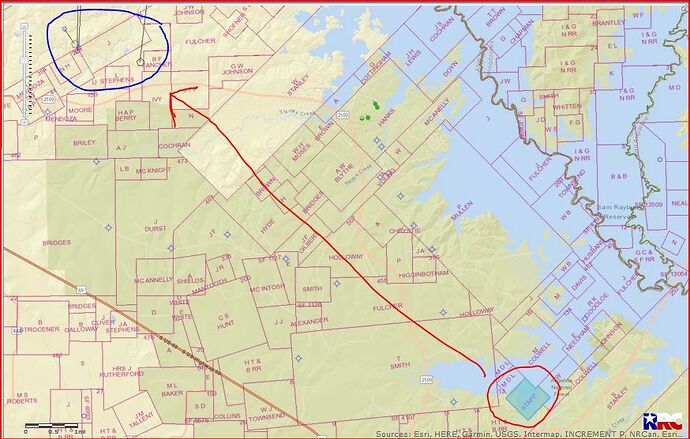
To the NW of your minerals several miles BP America Production Company is drilling some good Haynesville Shale gas wells(19,000’ to 20,000’)
This link is to an approved(September 24, 2018) permit for a well(API 005-30436) to your NW several miles:
http://webapps.rrc.texas.gov/DP/drillDownQueryAction.do?fromPublicQuery=Y&name=ROCKIES%2BGAS%2BUNIT&univDocNo=491972527
My opinion is not to sell at this time unless you need money. And the person wanting to buy your minerals probably won’t pay you but very little.
This GIS map will show you in blue (circled in red)where your minerals are located and the red line directs you to where the activity is.
CLICK ON MAP TO ENLARGE
Clint Liles

Thank you so much Clint_Liles!

