Among my grandfather’s papers is the receipt for oil rights transcribed below, written by hand on the back of a personal check. The story I’ve heard about it involved a handshake deal in a bar with a stranger. While I don’t seriously expect it entitles me to any cash, I’d be curious to know more about whether these tracts ever produced any oil or who the seller, W. K. Quigley, was (oil baron, con man, or just some guy?). Since there’s no Royalty Deed among his papers, and as far as I know he never received any royalties, I suspect it was never recorded anywhere, but is there any way I could check online? And can anybody shed any light on the Travis Building and who might have had offices there?
Thanks for any leads.
Jan. 27 - 1930
Received of Lt. Col. F.Q.C. Gardner – Eighty ($80.00)
Dollars as payment for a one/sixty-fourth interest in all oil
rights out of the 160 Acre Tract known as the Sebastian Tract,
or out of the 160 Acre Tract known as the Overstreet [??] Tract, in Frio
County. Royalty Deed to be delivered as soon as practicable.
Welcome to the forum. Always glad to see somebody willing to dig for information.
The only place you might find Frio County production history that might be as far back as the 1930’s is the Texas Railroad Commission’s archieves in Austin. RRC’s online records only go back to the 1990’s. In any case I don’t think you could pin down drilling that ever took place in a particular part of the county without more information, like the survey/abstract number, or Block and Section, of those two 160 acre tracts you mentioned.
The deed records in the County Clerk’s office for Frio County is a logical place to look for more information, but a quick check didn’t turn up anything there in the name of your grandfather or W.K. Quigley. Here’s a link where you can try you luck at free online searching in those records. Use the first pull down menu to select Frio County https://public.lgsonlinesolutions.com/ors.html
You didn’t say if your grandfather had lived in Frio County, or where you thought his dealings with Mr. Quigley might have taken place. The Bexar County
deed records show a guy named W.K. Quigley was doing business in San Antonio in the 1920 and 30’s, possibly in real estate.There’s also a Travis Building in San Antonio. It was completed in 1926 and originally was referred to as a “commercial” building but a couple of years ago was converted to apartments. I don’t know if Quigley had an office there or know what the “C. 1916” at the end of that notation might mean but thought this might give you a starting point.
Wow, very helpful. I’ll follow these threads. Thanks. I wish I’d known about this when I was in grad school at Austin in the '80’s.
At the time of the receipt, my grandfather would have been stationed at Fort Sam Houston near San Antonio. Also, the receipt is written on the back of a personal check from the “Commercial Bank of San Antonio”. A web search on “Quigley” and “oil” turned up a USGS report by someone who could be his son and a professor in geology.
I’ve found a record from around 1883 in the Texas General Land Office that seems to be a proof that one W.H. Overstreet [digitized as “Ovenstreet”] had occupied and improved a 160 acre tract in Frio County along with Daniel E. Johnson. I’m not sure I understand the document, but I think it’s giving them a land grant or homestead, and that Overstreet turns around and sells it to Johnson. There’s also a note that says “Patented Feby 18/84 No. 245 Vol. 15” by somebody Jones and a couple other notes I really can’t make out, maybe “mkd” something. A search on that number and volume takes be back to the same document. A survey of the land “beginning at a stake set for A. B. Witters” is part of the document (survey number 4 in Frio County) but I can’t decipher it further. The “District Class” is “Bexar Pre-emption”, abstract # 1025, file number 001460. The surveyor’s note says he has recorded it in Book [maybe “O”?] No. 1 page 103 on 31 Dec. 1875.
This is the only reference I can find to Overstreet in Frio County, and it seems like something that might be referred to as “the Overstreet tract” in 1930. Is there any information in here that could help me link it to Quigley or look up production records?
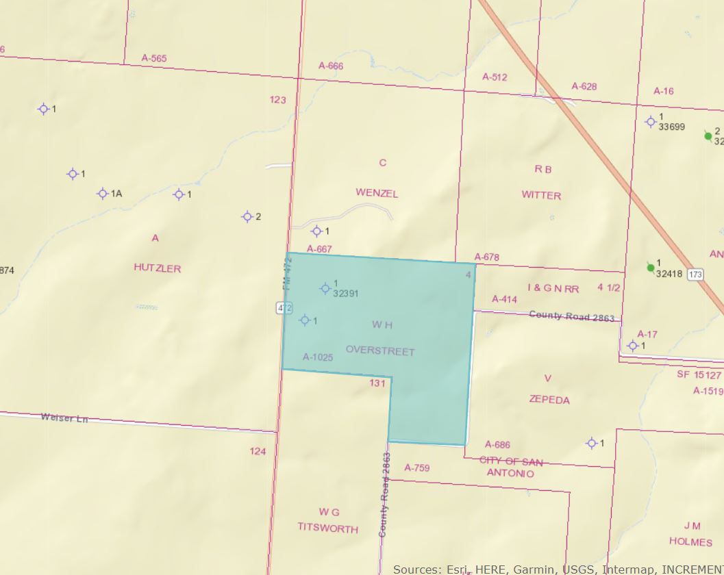
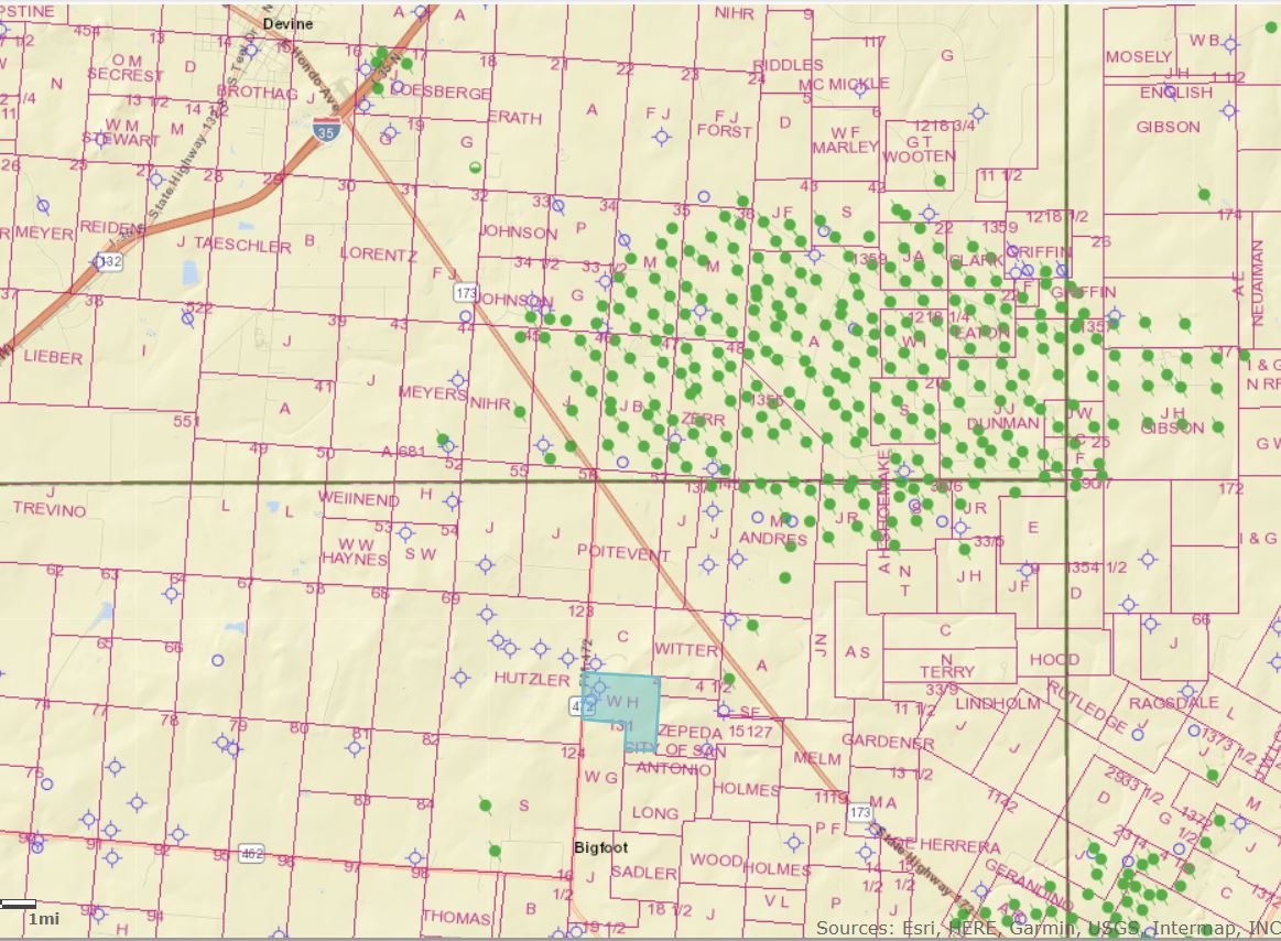
In case you haven’t seen it I’m attaching the current RRC map of W.H. Overstreet Survey A-1025 you found. The first view is close up and the second a wide view with that survey highlighted in blue.
Could be coincidental but the fact that Overstreet Survey contains 160 acres, matching the acreage amount mentioned in your old note, is interesting.
I don’t know how you can look for potential connections between that Overstreet Survey and Mr. Quigley without being able to do more detailed researching in the Frio County deed records than is possible online. You’d also probably need information from a “title plant”, which is the data base title companies use to index deeds and other recorded documents by the legal description of the tract involved in those documents rather than by the names of the grantors and grantees on those documents. It would cost something but if you contact a title company in Frio County they should be able to provide you a run sheet listing the recording information (volume and page number) and possibly the grantee and grantor on all of the recorded documents related to that particular survey. You might narrow your request to what was recorded between 1880 and 1940, and also ask for a list of anything recorded during that period showing W.K. Quigley as the grantee.
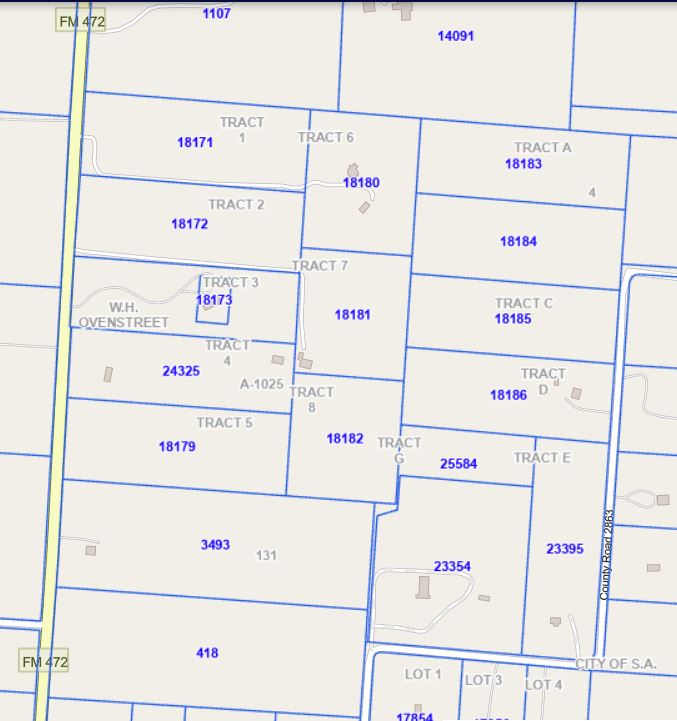
Since you seem to enjoy digging in the records you could also see what turns up through the Frio County Appraisal District’s site. Here’s a link to their interactive map https://www.friocad.org/home/map
At the bottom below is what their map is showing for the area around and including the Overstreet Survey. I thought there possible could be a single landowner on that 160 acres in which case you could use their name to run their chain of title and determine the past ownership of the mineral interest there. Unfortunately, that original 160 acre survey is now divided into a bunch of small tracts. If you got into the tax records for each of those tracts that are accessable through FCAD’s map each record would show the 3 or 4 most recent deeds on that tract. Using a random sample of those deed references you could check the deed records looking for the originally owner of the larger tract and the mineral interst.
If you figure out that this is the 160 acres where Quigley owned mineral interest you could then check RRC production records but from the map it looks like the two wells drilled within the survey were dry holes and most of the producing wells northeast of there are now plugged.