looking for more info my grate grate grandfather had bought 160 acre in 1903 and then also 160 acre in 1907. Their was a oil well on it it is in logan county OK S8 T17N R1W SE Mineral rights have been handed down and split from children grandchildren and now grate grandchildren. just looking for more info like how many shares are out their or any history
Welcome to the forum.
Do you know which quarter sections the separate 160 acres were? Such as NW4, SE4?
There were 20 wells drilled in section 8, but they are scattered about and not all would pertain to the family acreage. Only four are active now.
The forum cannot help you with the shares or percentages. You would need to track the deeds and probates through the county courthouse to determine who got what or if there were any sales. You can search digitally on www.okcountyrecords.com for free. I used the advanced search and type in my relative’s name(s). The online records only go back so far, but that will give you a start. Freee to look, costs a bit to print. You can go to the county and look through the abstract books for get the rest of the info or you can hire a landman to do it.
s8 t17N R1w C 1/4 ne 1/4 ne 1/se also found 3508320646 Koehn#2 and 3508300282 Koehn#1
Underwood Oil and Gas is listed as the operator.
0817N01W S2 NE SE SE
Koehn #1 was drilled in 1950. Very sporadic pickups for oil in the last few years. 33 bbls in 2021, 30 bbls in 24.
https://public.occ.ok.gov/OGCDWellRecords/DocView.aspx?id=2198692&dbid=0&repo=OCC&searchid=c2c8516a-bbac-407c-8a14-f18443602c7f
0817N01W C NE SE SE Koehn #2 was drilled in 1977. Very sporadic pickups for oil in the last few years. 56 bbls in 2021, 50 bbls in 24. https://public.occ.ok.gov/OGCDWellRecords/DocView.aspx?id=2235000&dbid=0&repo=OCC&searchid=c2c8516a-bbac-407c-8a14-f18443602c7f
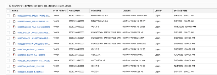
is their another well close that was drilled in like late 1990s early 2000s that they drilled a new well
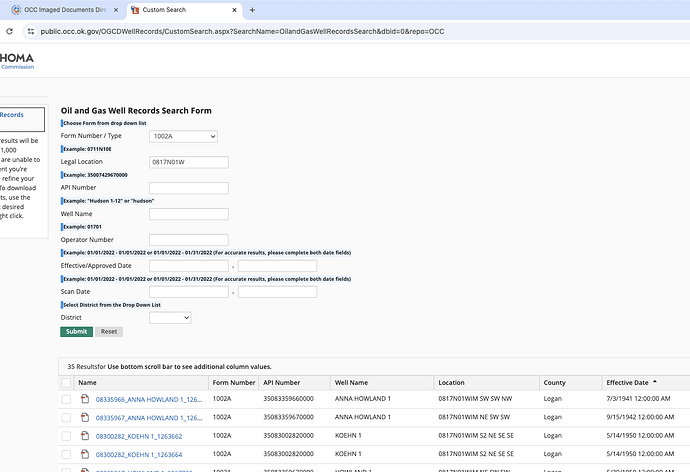
You can search on the OCC well records site. Fm 1002A are the completions.
You can sort by effective date. Here are the most recent wells.
sorry for so many questions just trying to learn what is the bbls stand for
Questions are what the forum is about. BBLS is the abbreviation for barrels. MCF is the abbreviation for 1000 cubic feet of natural gas.
This topic was automatically closed after 90 days. New replies are no longer allowed.

