I’m wondering if anybody has info and/or maps for any and all activity on subdivision18 of the Young county school land. Abstract number 1285. Or information pointing me to where I can look for the info. I am new to this type of stuff. Any info would be helpful.
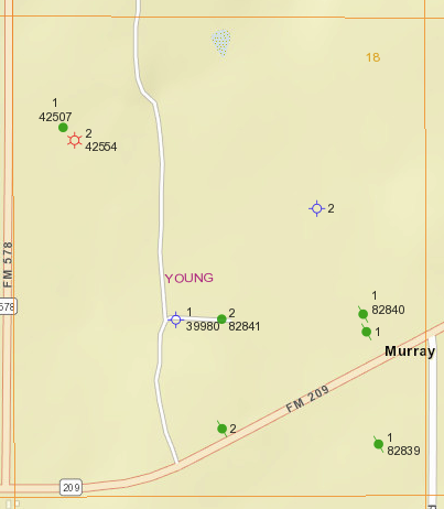
Here’s a map of this subsection:
There are three wells that are still productin, 1-42507, 2-42554 and 2-82841. The others have either been plugged (the green dots with a slash through them) or were dry holes (the blue circles over a cross. You can view this and any parcel of land in the state in the Railroad Commission’s GIS map (Public GIS Viewer (Map)) After launching the map, on the menu bar at the top, first click on the magnifying class icon and choose Surveys from the dropdown menu. Select your county and enter the abstract number, then click Query. The resulting survey will be highlighted - you can clear the highlight by clicking on the red dot icon on the menu bar. Once you have the survey you want, find the icon with an I in a circle. From that dropdown menu, choose Wells. This will allow you to bring up detailed information about a well by clicking on it in the map.
Hope this helps!
That’s some really helpful info. Many thanks
This topic was automatically closed after 90 days. New replies are no longer allowed.
