I found the two attached leases on Texas File. This is something my mom did after my father passed. She would have had no idea what she was doing. Just as I don’t now.
These two docs are the only thing I found in Gaines County on TexasFile.
My questions are:
Did she do anything harmful by doing these lease deals?
How can I find out if anything ever was ever drilled?
From these two leases can it be known if she had the entire lease rights or only a small part?
How can I find out if these leases are mine now?
I hoping these are basic questions and easy to answer. Sorry if it’s asking too much. In the early learning curve here.
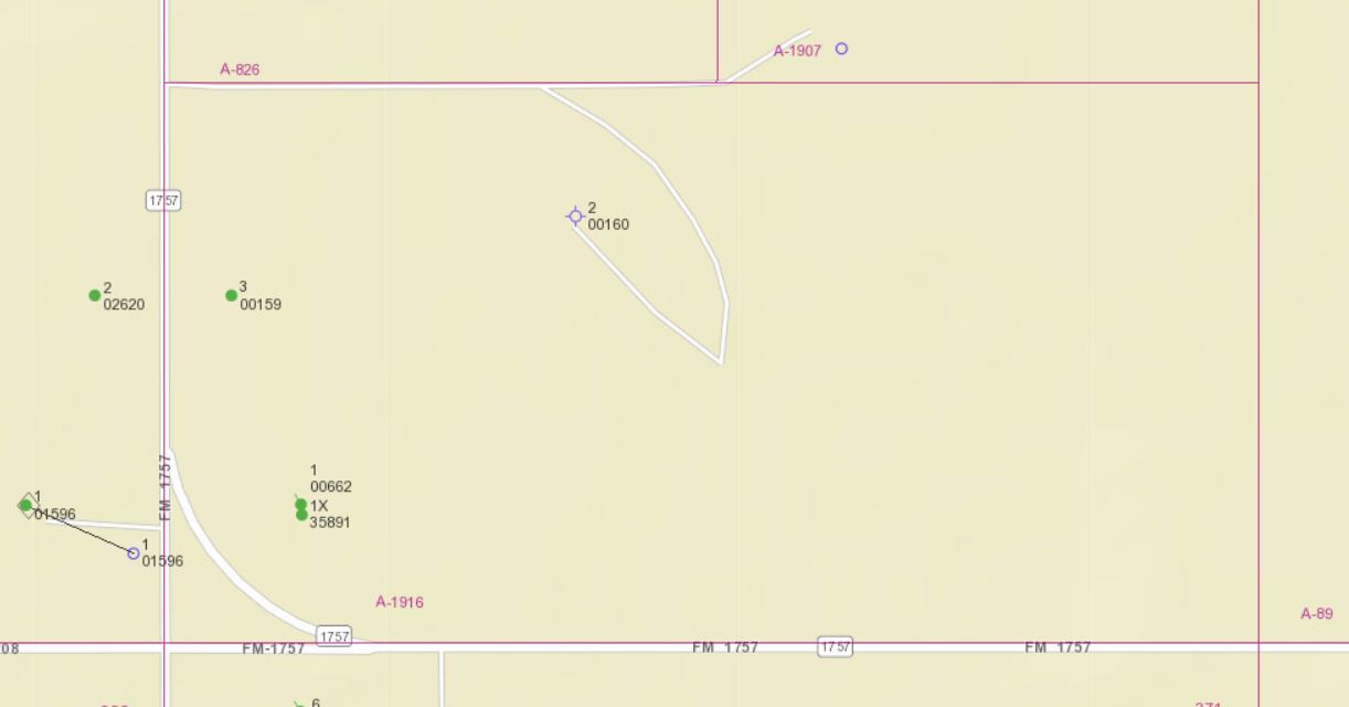
Below are the current Railroad Commission maps for the two areas of Gaines County that are described in the leases you posted.
In Section 372 the map shows two vertical wells, each in an 80 acre unit that covered 1/2 of that south half of Sec. 372. The well marked #3 (called the Peck “B” #3) was drilled in 2002 over the next five years made a total of about 93,000 barrels of oil and a little gas. The last production was shown in 2007 but the map doesn’t show that it has been plugged and abandoned.
The well that’s near the south end of the section, marked 1X (called the Peck “A” 1X), was drilled in 2013 but it didn’t show any production until 2016 and from then until 2022 when it was shut-in it only made a toal of 130 barrels of oil. Since that second well was drilled after your mother signed that lease I guess it’s possible that 80 acres unit could have included her mineral interest. Although neither of those wells are producing a company called Phillips Operating LLC is still shown as the lease operator.
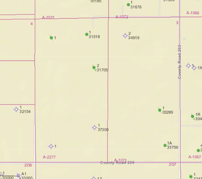
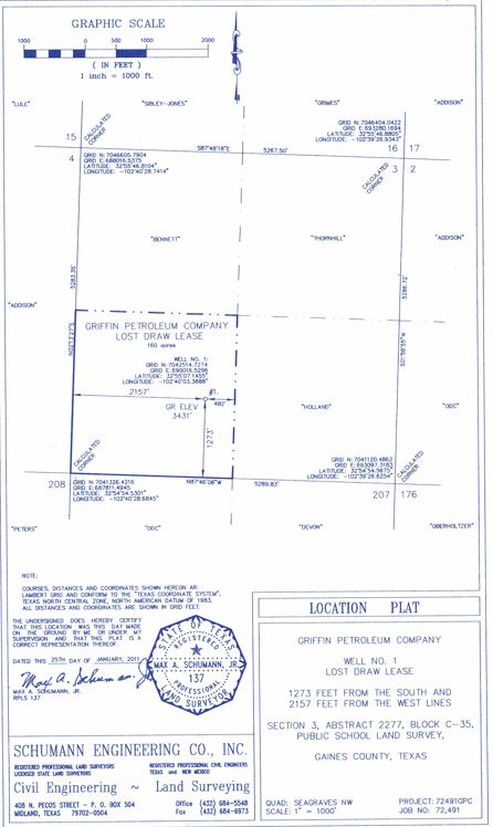
On the second map covering Sec. 3, Blk C-35 shows two vertical wells in the SW quarter of that section but both were plugged as dry holes. The well furtherst south appears to be very old, probably drilled sometime in the 1960’s, but the other one, marked #1 37300, was drilled by Griffin Petroleum, the company your mother leased to. RRC’s records show that well, called the Lost Draw, was plugged Feb. 20, 2011, less than a month after your mother signed the lease with Griffin. The plat showing the location of that well is attached below the RRC map of that section.
On your other questions, I don’t see how your mother might have “done anything harmful by signing these leases”, unless for some reason you think she didn’t inherit that mineral interest previously held by your father after he died.
Determining the amount of mineral interest your father owned in those two sections would require some more research in the Gaines County deed records. Since you already know how to use TexasFile. If the description in the leases doesn’t give a deed reference that will get you into the chain of title, try searching your father’s name (or the names of others he might have inherited or otherwise acquired that interest from) in the grantor/grantee indexes trying to find the deeds where he gained title to that interest.
Regarding the current status of those leases, the one with Griffin Petroleum was only for a one year term and should definitely be expired if that well was plugged as a dry hole. I expect the lease with RioRancho in Sec. 372 is also expired but since the wells in that half section aren’t shown as being plugged you might try checking with Phillips Operationg on the current status of that lease.
That’s incredibly helpful Dusty1, I will see if I can track down further info per your comments. TexasFile had no further records for my dad or mom for anything else in Gains.
Looking at gainescad.org I only find info for 2016 & 2019
BENNETT ESTATE 85062471-000 WTG EXPLORATIO/SEAGRAVES, S. (SILURO- BLK C-35 SEC 3 /PSL (NW4) SUR 160.0000.0032960000R
Where my mom is 100% owner, mineral value $506, taxes $11- $14
Does that imply production activity? And no production in years no listing comes up?
Mineral holder has 2016 & 2019 as well.
And now, I just noticed there is a division order from WTG Exploration but it’s for W/2 Sect 3, Blk C-35
How am I to think about the discrepancy between NW/4 and W/2?
And does it makes sense that gainescad.org has no info beyond 2019 when I’m getting a division order now?
And is it possible that my dad/mom have a lifetime mineral lease on this?
Just more fumbling around trying to learn something…
I’ll take a shot at answering your questions, not necessarily in the order you asked. Understand there is a lot of guess work involved and may be off base.
From what you found on GainesCAD I’m thinking the mineral interest your parents owned may have covered the west half of Section 3, Blk C-35, not just the SW 1/4 that was covered by that 2011 lease to Griffin that you had originally posted.
If that’s right your father may have signed an earlier lease with WTG Exploration that covered the northwest 1/4 of that section. The WTG Bennett Estate well you found on GCAD is the well shown on the RRC map near the upper boundary of Section 3 that is marked as 1 31518. RRC records show WGT drilled it in 1979, so you might check TexasFile for a lease to WTG that was a year or so before, or after, that date. The production records show WGT Bennett Estate is still producing a little natural gas (40 MCF/month) but up until November, 2022 it had also been making about a tanker load of oil every two to four months. After that the oil production droped so low it took until February of this year to accumulate another 67 barrels and no oil has been reported as being sold since then.
I don’t have a guess why GCAD is only showing taxable value in 2016 and 2019 because RRC shows the Bennett well was producing in other years.
When you say “I just noticed there is a division order from WTG Exploration”, do you mean WTG sent you a division order to transfer the interest in the Bennett Estate will from your mother into your name? If that’s right you might ask if they can provide you a copy of the lease, or the recording information, on the lease that covers that royalty interest. It’s surprising to see a well that’s produced that long but also had the same operator all those years.
When you ask if it’s possible your parents have a “lifetime mineral lease on this”, I not sure what you mean. If your father owned mineral interest in the west half of Section 3, and he (or someone he inherited or otherwise acquired that mineral interest from) signed a lease with WTG, and there has been enough ongoing production from a well that was covered by that lease to maintain the lease (referred to as being “held by production”) then that lease would still be active. If both of your parents have died in looks like the ownership of the mineral interest they previously held, and the production from that existing well, would pass to their heirs.
If you haven’t looked at the State Comptroller’s Unclaimed Property website check to see if the State is holding any royatly payments in your father or mother’s name. https://www.claimittexas.gov/