Received an offer for assignment on six interests I own in Eddy County, NM

A week ago, I received an offer from a land services LLC interested in acquiring the royalty assignments to six different leases I own a portion of. I have often sold or retained various rights, but in 2010, I accepted an offer that I still regret. My decision was based on my faulty research, and I don’t want to fall into the same trap if I can avoid it. Some of my current research reveals that the long-term objection to drilling areas dominated by Potash mining has been mitigated because of pooling islands and horizontal drilling. I have looked for the owners and production entities for the following and got close, but never the exact pieces. Any help or knowledge in these areas would be greatly appreciated.

S2SW4, SE4 of Section 8, Township 21 South, Range 28 East, Eddy County, NM

NW4NE4, NW4 of Section 17, Township 21 South, Range 28 East, Eddy County, NM

E2, SW4 of Section 18, Township 21 South, Range 28 East, Eddy County, NM

E2, E2W2 of Section 19, Township 21 South, Range 28 East, Eddy County, NM (Save & Except the Big Eddy Unit #140 wellbore.)

N2NE4, S2NW4, E2SW4 of Section 29, Township 21 South, Range 28 East, Eddy County, NM

Lots 1-3, E2W2, E2 of Section 30, Township 21 South, Range 28 East, Eddy County, NM
1 Like

The interests you listed are just west of the Potash mine. The township has been generally quiet, but activity has picked up some in the last 12 months. I would certainly get another offer to make sure the offered pricing is competitivie.

Thank You, Pfears, I have already heard from others who are interested in these royalty interests. It seems you are correct in your assessment. Obviously, there is interest in Township 21, range 28 east, Eddy County NM.

Yes that area has good rock and ORRI carries a nice value there. If you’re a seller, wait to receive multiple offers. Ask them to submit offer on a per NRA basis. Do you know how many NRA you own?

I do not know how many NRA there are, I will probably have to go somewhere and pay to see specific acreage. I have been informed that EXXON owns these pieces, so I will continue researching. Thanks

Any interested buyer should send you an offer that shows how many NRA you own and the offer price per NRA. If they aren’t willing to do that then they can kick rocks.

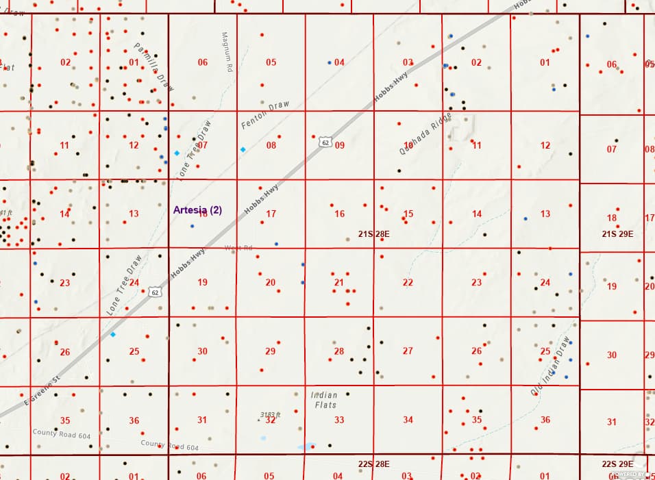
You might want to slow down on selling and find out more. Section 20-21S-28E has four permitted wells by Avant Operating. Offers to buy frequently are mass mailed out to everyone with nearby sections to sections with pending permits. Secs 1 & 2 in your township also have pending permits. Township 21S-27E has quite a bit of horizontal drilling.

New Mexico Oil & Gas GIS Map ArcGIS Web Application 153

1 Like

It Never ceases to amaze me how many people are so quick to sell their interest in mineral rights!

Ms. Barnes Thanks for the map and your interpretation of the activity in the sections I participate in. I have only received one mailed offer. The three others have been sent directly to my cell phone, which is a bit creepy. Sections 8, 17, 18, 19, 29, and 30 are tight little areas. Section 20 is in the middle of them.
I need to know the acreage involved in each section. I know it’s S2SW4, SE4 of Section 8, but I can’t get access to those specifics, and without them, I have no idea how many acres are involved. I was teased with $7k per acer and 1/4 royalty. I will try to track down Avant Operating and see what they say. Again, I greatly appreciate your expertise. jmorran

If you could lease instead of selling, you might end up with something nice in the area. Get an attorney to help you with the clauses. The landman should have your net acres. You have the descriptions listed above. You probably have some smaller net acres than what is listed as gross.

As others said, this isn’t under potash. BUT it is in Big Eddy Unit and hard to see how it gets drilled by Exxon any time soon unless something changes drastically. They haven’t drilled a well in western BEU in 7 years and have a couple thousand wells still to drill in Poker Lake Unit (better rock).

You know the (gross) acreage that is involved, you need to know the ORRI % in each of the tracts. As somebody else said, the easiest thing to do is just ask whoever offered you to tell you how many NRA they think you have in each tract.

The Avant story is a bit confusing. Everything you are listing is a Fed lease. Presumably an old Federal lease. Yet Avant is offering you lease terms?

Thanks for your insight.

I have been researching Division Orders and interest transfers from probate(s) and now know the acreage, 320, and ORRI %s. Most of these pieces were originally leased by Bass and Bepco, later sold to XTO, and are now part of EXXON.

I recently emailed the party that made the first offer, asking for more details, but they haven’t responded yet.

I only glanced at this prior. It looks to me like you have an ORRI in Fed Lease LC 0059365 that covers those lands. Single lease. 2553.6 gross acres.

Take your override %, multiply by 2553.6, then multiply by 8. That is your NRA.

For example, 0.1% ORRI would be 0.001 x 2553.6 x 8 = 20.4 NRA (I have no idea what your ORRI is)

Yep. It’s in Big Eddy Unit, operated by Exxon after purchase of BOPCO assets in 2017.

2 Likes

NMoilboy, Thanks for all the info. One of the interested parties I am dealing with came up with 38.8 acres at $7k per. No override. That’s a nice number, but looking deeper, using the original BEU Gas Map from BEPCO in 2017 that I discovered buried in my O&G files, I see that the Fed. Lease LC-059635 areas are all over the sections in discussion in township 21 S, range 28 E.
I told the prospective buyer we needed to investigate the lease breakdowns more thoroughly to firm up the acreage. The ORRIs are established. I am leery of posting the map from BEPCO on this site, but I would like you to see it. Bottom line: without your knowledge and generosity, I’d be lost in the wind in this, and I’d be 100% vulnerable. Happy 4th jm

I’m not sure what your “no override” means. You have an ORRI in this Federal lease, it appears. Somebody is, I assume, trying to buy your ORRI at a rate of $7k per net royalty acre. That is what would make sense to me based on this thread. I’ll assume “acre” means “net royalty acre”.

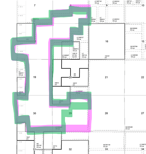
Here is the lease on a publicly available map in pink. What you described is the green line. I failed art class. It matches your description other than Sec 29, so not sure what is going on there. But your description would be something like 2234 acres (2554 in the pink minus 320). All inside BEU, held by XTO/XOM.

As you said prior, you know the ORRI%. See if you get the same number of acres (NRA) that the buyer is coming up with. Then at least you are on the same page and you can make sense of it. Sometimes people will tell you that you own more acreage than you actually do so that the total $ is higher (but will go down in due diligence/title).

Cheers

1 Like

Hello Mr. @NMoilboy , On July 3rd, you wrote in response to my dilemma about what you said was a Federal Lease and how to establish the NRA was a formula you provided:

"I only glanced at this once. It looks like you have an ORRI in Fed Lease LC 0059365 that covers those lands. Single lease. 2553.6 gross acres.

Take your override %, multiply by 2553.6, then multiply by 8. That is your NRA.

For example, 0.1% ORRI would be 0.001 x 2553.6 x 8 = 20.4 NRA (I have no idea what your ORRI is)

Yep. It’s in Big Eddy Unit, operated by Exxon after purchase of BOPCO assets in 2017."

I have been in negotiations for months now and returned to your post and saw something important that I let slip by: You wrote…

“Take your override %, multiply by 2553.6, then multiply by 8. That is your NRA.”

I am negotiating to sell six different properties in the T21S, R28E in the Big Eddy area. In one section the interest is 5/24 x 95% x 1% x 240/320 ORI (.00148438) .00148438 x 2553.6 = 3.79051277 x 8 = 30.3241021 NRA. Is that correct? If it is I’ve been shorting myself the x8 part. Please let me know is possible.

Thanks jm

If your ORRI is .00148438 then your NRA in that section is .00148438 times the lease acres in that section, times 8. So if in the above, we are looking at section 19, where the lease covers 480 acres of the Section, then your NRA there would be .00148438 x 480 x 8 = 5.7NRA

“Take your override %, multiply by 2553.6, then multiply by 8. That is your NRA (in the entire 2553.6 acre lease)"

Which here would be the 30.3 NRA. But…

As I mentioned above, your legal description seemed to be less than 2553.6 gross acres, more like 2234 acres. Which would make it 26.53 NRA.

That clear?

No. I need more clarification now than before.

                Property Description:

N/2, SEC 29, T21S, R28E NMPM, EDDY COUNTY, NM CONTAINING 320 ACRES, MORE OR LESS. INTEREST: 5/24 x 95% x 1% x 240/320 ORI (.00148438)

Initially, I took .00148438 x 5223.6 = 3.790051 as the NRA. I didn’t multiply that by 8. I assumed that 5223.6 was used across the board. I am still determining my total NRAs. Each Division order is usually 320 acres, one 313.4, another 315.8.

With a better understanding of the formula, I tried this: .00148438 x 320 x 8 = 3.8256128 NRA - this is the NRA for that one property? .00148438 x 5223.6 x 8 = 30.3241021 - this is the total NRA for all the acres in the Fed Lease in T21S and R28E?

The irony is that a prospective buyer is using my NRAs. Who’s steering the boat here? Thanks for taking the time to respond. Your knowledge is invaluable for those like me.

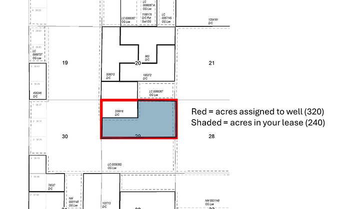
Ok. I think I got it. The .00148438 is your decimal in a well. Specifically it looks like the Big Eddy Unit # 39. That well is dedicated to the North half of Sec 29. So, to figure out your ownership of that well, they see that your lease occupies 240 of the 320 acres. So they take your ORRI, times 3/4 (240/320) and they get your decimal in the well.

But yeah, if you take your decimal in the well and multiply it by the dedicated acres (320) and then by 8, you get your NRA inside that 320 acres. Here is the N2 of Sec 29

So, to me, it looks like your ORRI in the whole lease is 5/24 of 95% of 1% or .00197917.

Overall, IF you own in the pink line above which is the outline of LC 0059365, I would then think your nra in each section is something like this:

Your description above for the acreage was more like the green line in my prior post, so its a bit less NRA and its not 240 acres in the BEU #39, so the whole thing starts to break down a bit and get confusing as you can’t just own the green and also have 240 acres in the N2 of Sec 29.

1 Like

It will take me a day to digest the work you just presented. Your latest post has helped me better understand the mess uninformed owners address. My kids, thank you.

I’m a late-learning ORRI owner and am beginning to see the lack of transparency in this industry. You are helping me discover my NRA and, more importantly, how to determine it. This is a great tool for the less informed.

Thank you