S:12, T:25s, R:28e / S:11, T:25s, R: 28e

Does anybody (maybe @NMoilboy :slight_smile: ) know more about this area? Is there good activity there?

I have just inherited some mineral rights in this areas. I am pretty clueless about everything, and just trying to educate myself. Thanks to this forum, I’ve figured out how to look them up here: NM Oil Conservation Division - Imaging System

As stated in the title, the areas are: S:12, T:25S, R: 28E & S:11, T:25S, R: 28E

I see a list of 12 total wells when I plug in these two properties.

3 are “active”, 8 are “new”, 1 is “cancelled”

I don’t really know what that means in real-life terms.

So I’m hoping that somebody more familiar with the area could tell me more? Is there good activity there?

QUESTION 2: Also, my brother says that he doesn’t recall seeing checks from some of the producers listed (he’s the only one who has seen the checks that previously went to my father). Does that mean that some of them might owe back pay? If so, is there a way to check that?

Thanks again for any and all info!

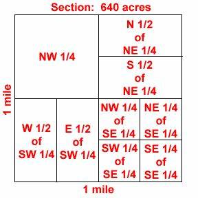
Hi Hannah, I inherited mineral properties from my father also and it can be confusing. A section is 640 acres. If you have the SENE in sec 12 25s 28e, that would be NM’s unit h, containing 40 acres. Sec 12 25s 28e, with the SWNW would be unit e, again 40 acres. You probably own a part of those units, so your interest would be a fraction of the 40 acres. When you look up the sections in NM’s OCD, you also have to determine if the wells you find contain your unit. In Sec 12, it appears to me that you should be being paid for the Illustrated Man Fee Com #1, a 160 acre well with units d e l & m, with COG operator. In S 11, it appears to me that you should be being paid for the Hoss 2 11 W2BO Fed Com #1, a 640.57 acre well with Mewbourne as Operator. I’m not sure about the Malaga 13 DM Fed because it comes up in the search but the acreage description is for S 13. We have interest in the Illus Man Fee & The Hoss 2 11 W2BO also. We get information on EnergyLink for these and other wells. You might explore this possibility. My sister and I took 2 3-day courses at the Royalty Owner Institute that has helped us immensely, especially the one taught by David Wallace. Good luck. Mollye Morris

1 Like

Thank you so much @Mollye_Morris for your helpful reply! You actually brought up one of my questions (that i didn’t ask) which was: should we be expecting checks from ALL of these producers?

You are right when you say that I only own a portion of the acres. Actually, between my other brothers and sisters we own 80 acres of mineral rights on these 2 properties, split between us. (My father actually owned 160 land acres, but only 50% of the mineral rights on those acres, so 80 acres of mineral rights). But for the sake of clarity, I’ll just ask questions about the 80 acres as a whole (not just my smaller part of it).

Since the 80 acres are on these 2 sections (“properties” as they are called on the document), does that mean that we should be receiving checks from EVERY well on those 2 properties?

And if not, how am I able to tell which wells we should be expecting payment from?

If you have the SENE in sec 12 25s 28e, that would be NM’s unit h, containing 40 acres.

Thanks for this additional information! How were you able to find that (the unit letter)?

Thank you so much Mollye!

Hey.

Oftentimes its hard to go through the NMOCD site because it only lists well by their surface location, which doesn’t always paint the whole picture when we are talking about horizontal wells.

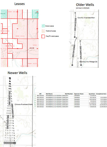
Here is a bit of a map of those 2 sections. I don’t know exactly what you own but it should be somewhere in the “white” part of the Leases map, private/fee land. Which means you should have some interest in the horizontal wells drilled in the Western half of Sec 12 and 13 (or 12 and 13 combined).

There are 3 older wells in the W/2 that were mentioned by Mollye. There are also 7 newer Cimarex wells that happen to have surface locations in Sec 1 but will be producing from Sec 12 and Sec 13. Riverbend Federal wells. On the bottom left.

Two of the Riverbend wells have been producing for a year. Four more should have just come online in 2020, and there is one other that may not have been fracked yet.

You should in theory be getting paid for all of those wells. Well I guess its possible that you might not be getting paid for 3001540974, depends where in the white you own. What your interest is in the wells depends on where you own and how much.

If your family really has 80 net mineral acres then you should be receiving a decent amount of revenue. I would contact the royalty owner relations/land division at Cimarex, COG, and Mewbourne. If you are NOT currently receiving anything ask if they show you (or your father) are in suspense. Basically find out if they show you or your ancestors as an owner, and if so figure out how to get yourself into pay status and collect any withheld monies.

Thats of course assuming any of these departments at these companies are currently functioning at this time.

Hope that helps if you need clarification give me a shout.

1 Like

Hi Hannah, I don’t remember where I found the NM ocd unit system, but I’ve copied it below. I’m not sure it will display correctly, but going from left to right, the units are d c b a (first line), e f g h (second), l k j i (third) and m n o p (fourth).

I’m also copying a section because your description confused me. The SENE and the SWNW should contain 40 acres each, which would only be 40 net mineral acres if only 50% of the minerals in each area are owned. To verify exactly how much you own, you can examine the deeds. If you don’t have those, you can do a grantor/grantee searches for them. I use TexasFile.com (they also include NM), courthousedirect.com and countyrecords.com. NMOilBoy has great resources that I don’t have because he could determine that the Riverbend 12 13 wells had been drilled already, which is not noted on the NM OCD site yet. That’s exciting news to me since we have minerals in those - if the price of oil will go up!

Thank you, NMOilBoy, for your information.

Mollye

NM OCD Units: D C B A E F G H L K J I M N O P

1 Like

I just realized that for some reason I read her note as Sec 12 and 13. My bad. Hence the map of Sec 12 and 13.

Yeah should have interest in the two Mewbourne Hoss wells in Sec 11 also. Not in the Malaga wells in Sec 13.

The Hoss APIs are: 3001544153 and 3001544152.

This is really helpful information. Thank you so much to you both!

Thank you so much for your reply, I am getting closer and closer to understanding (and then realizing how much I don’t understand).

I just learned about these mineral rights a few months ago. And according to my brother, my father was indeed receiving quite large checks (sporadically - this is one reason I want to look into this. My father didn’t really know what was happening, and he had nothing to do with negotiating anything. He just started receiving checks out of the blue apparently. I want to be more on top of things. And to do that i need to understand who is really drilling, where, and what our actual rights are.) He did receive offers for up to $2mil. (last year of course!). This was all complete news to me.

I have just gotten off the phone with my brother and there is an entirely new element that I didn’t even know about previously:

(PLEASE correct me if I am wrong in the following. This is what my brother has just told me, which was told to him by the woman he spoke with at Cimarex when he called them to ask why they were sending my father checks, when we didn’t have a lease with them).

SHE said:

Apparently in New Mexico, beyond “sections”, there are these things called “drilling areas”, that group together several sections. And New Mexico bases royalty payments on these drilling areas, not the sections.

So for example there is one drilling area that contains BOTH section 12 AND section 13. Now even though my father owns no land (or mineral rights) on section 13, because section 13 is in the same “drilling area” as section 12, he gets royalty checks for activity on section 13. (when I say “my father” I mean it interchangeably with myself)

So now apparently I need to figure out the drilling areas that each of his sections are a part of.

Another interesting tidbit is that the biggest checks he was receiving came from wells that were not on his section, but were in the drilling area that comprised his section. Or at least according to my brother.

Very complex. I’m going to call the county office tomorrow to see if I can understand this all better.

(PLEASE please please correct me or clarify me on what I’ve written that is wrong. This is like 4th hand information)
Operators put together drilling units that have a spacing that will (theoretically) drain that unit properly. It may consist of two or more sections. Any well within that drilling unit will pay all the owners in the drilling unit according to how much acreage they own. See if Cimarex will give you a plat of the spacing area involving your acres. The NM oil and gas commission may also have plats. There are several knowledgeable NM folks on the forum that can get you started on how to search there.

Awesome, thank you M Barnes!

@NMoilboy , thanks again for your message it turned out to be very helpful.

Could you possibly give that same type of information on section 11? (S:11, T:25S, R: 28e)? Or is it possible to get access to the software you used? There are a few operators listed in this ocd website for that section that haven’t paid anything.

There is also an operator listed in section 12 (ocd search) which you didn’t mention. I"m wondering if there is a reason? (obviously you know how to interpret the data better than I do):

ILLUSTRATED MAN FEE COM #001H, by COG

https://wwwapps.emnrd.state.nm.us/ocd/ocdpermitting/Data/WellDetails.aspx?api=30-015-45095

Thank you again for your help!

[wild goose chase]

So I called the Eddy county assessor, the Eddy county clerks office, and the state land office (oil and gas dept) and none of them were able to give me any information.

The state land office looked at my areas, and said "since none of the leases on this land are owned by us, and they are private leases, we don’t keep track of them and therefore have no information. call the county clerk office, they should know about private leases and land. "

The county clerks office said "we only keep track of specific leases, so if you have a specific lease I can look it up for you. But we don’t keep track of drillers, we don’t keep track of operators. I can’t tell you who would be drilling in your section (or under it). Somebody is probably keeping track of that information, but I don’t know who, and it’s not us. "

Since the royalty checks that my father receives have nothing to do with leases that he personally owns, it seems like it’s really hard to get any information.

What I really want to know is: Given the sections that we own, who are the operators either ON it or UNDER it, or RUNNING THROUGH it (or the drilling areas that they belong to) that we should be receiving royalty from, given the state laws?

It’s interesting that nobody seems to know that. I would assume that it would be tracked somewhere, no?

Start with the operators on the checks that you have. That is your first link. Are there well names or just section names? Ask them for copies of the Division Orders that go with your checks. Ask them for copies of the leases and if they won’t give them to you, ask how many net acres you have, what is your royalty and what is the spacing of the drilling unit and what sections does it cover.

The New Mexico Oil Conservation Division is a good place to get familiar with. I am sending the link to the wells, but look at the headers at the top and look in those areas.

http://ocdimage.emnrd.state.nm.us/imaging/WellFileCriteria.aspx

Thank you M Barnes, I will do this. I was hoping that the state might have some info, but I see I will have to follow the trail of crumbs back to the source. :slight_smile: I personally haven’t seen any of these checks, but I will ask my brother these questions.

Hi Hannah,

I’ll try to reason through this with you and possibly learn more.

It doesn’t make sense to me that your father will get payments from a company unless he has a lease with them. Is it possible that your father has a lease with Mewbourne for the 30-015-44153 HOSS 2 11 W2BO FEDERAL COM #001H.
That well is located in sec 11 25s 28e with your unit h as part of its pool. On the OCD website, you can choose ‘surface or bottom hole locations’ instead of only ‘surface’ with the results showing horizontal wells start and finish points. You should be able to locate any wells on your mineral rights.

If you register with the 3 sites I told you about in an earlier posting, you can do searches on your father’s name as grantor to see who he granted leases to. From that you can pay to download the files to read them. I think it ranges from $3 to $6, or the Eddy County Clerk’s office is very helpful: Phone: 575-885-3813, and only charges $1 ($2 for a certified copy) if they’re open. I gave them the book, volume and page number(s) from a search of the document I needed so you’ll need to do a search to find those facts first. If you want to give me his name, I don’t mind checking it out. Even if a horizontal well goes across multiple sections, they still have to receive leases from mineral owners whose minerals they harvest. If a horizontal well’s take points (locations where they bring the oil/gas up from) are on your land or mineral rights, you should have the opportunity to negotiate lease terms and receive a bonus for a granted lease. The companies should give you the particulars, but it’s also good to be able to double check their figures. (It is possible for a company to record only a memorandum of lease, which says who the grantor & grantee are, and the location. If that’s the case, the company who leased would be who would have to give you a copy of the exact lease. You’d still have to do the search to find out who the company your father leased to is. In this instance it could be Mewbourne, but it could also be another company who also has working interest. Either way, Mewbourne should be able to give you a copy, I think.)

I found 2 instances of companies producing from acreage where we had mineral rights, but in their defense, the amount was very small and one of the companies didn’t receive the information from a company that they had purchased. The other instance was very small also, and we were given the option to join in the 3 wells that had been drilled. They were producing so there was no danger of a dry hole, but we chose to receive a large bonus instead. I’m telling you this because if the company has drilled without contacting or leasing from you, you would probably have the option to join in. The Hoss 2 11 W2BO well has been very profitable so it would be worth considering. You would be liable for your percentage of the drilling costs, but would receive 100% (minus expenses) vs 25% for the typical lease. I’m not really familiar with working interest although we inherited a small number of very old wells that my father had joined in. Working interest owners are also responsible for plugging expired wells also. I’d confer with a lawyer before making decisions about this though.

My thoughts are to find the lease(s), unless there’s some reason where one is not necessary that I’m clueless about. Definitely a possibility :slight_smile: There’s a lot to learn about oil and gas.

Mollye

Thank you Mollye, you really are too kind. This is all super helpful information. I am going to forward this to my brother (since he is the one insisting that there are no leases).

Thanks for the heads up about the well too!

@NMoilboy, I have finally figured out where you got the images for the “leases” map you uploaded (ArcGIS Web Application)

But I cannot figure out where you got the images for the “newer wells” and “older wells” images.

It looks like those images are showing the horizontal flow of each well. Is that correct?

Can you tell me where you find those maps? I tried every map layer on nmocd, and none of them gave me images like those.

thank you again!

new to this forum , dont know where to post so hoping someone who knows what is happening in and around sec19 T18S R31 E and what would be a good leasing bonus for farming out an existing lease.

This topic was automatically closed after 90 days. New replies are no longer allowed.