I have a number of old Texas deeds and invariably they include references to tracts and lots within a subdivision. While it’s fairly easy to find abstracts / sections / blocks on the RRC GIS - there’s no ability to see at a more granular level. Is there some source that folks have used and been successful in finding plats / maps that have the subdivisions and lot descriptions??
below is an example
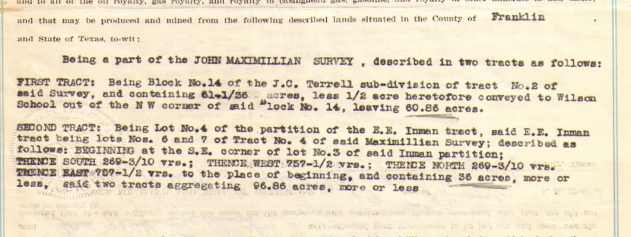
being block 14 of the JC Terrell sub-division of tract No. 2 of the said survey
another example
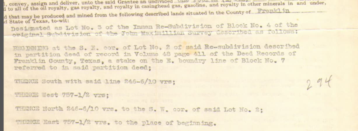
being lot no. 4 of the partition of the EE Inman tract, said EE Inman tract being lots nos. 6 and 7 of tract no. 4 of said Maximillian survey
I inherited mineral interests in Texas but I’m having a HARD TIME knowing how to look-up information based the legal description I received. I’ve been able to look-up oil permit and APIs in New Mexico and Oklahoma using SECTION, TOWNSHIP AND RANGE, but the legal descriptions for Texas are much different and I don’t know which search tool to use to get oil permit, API and completion information.
Here are two examples of legal descriptions I’m trying to decipher:
CROSBY COUNTY
E/2 = 1/4, N/2 SW/4 = 1/8 mineral interest in N/2 SW/4 Section 75 Block 8, H&GN Ry. Cert. 12-2382
GARZA COUNTY
1/4 mineral interest SW/4 Section 63, Block 8 H&GN Ry., 160 acres
Here’s link to a post on the forum that I found. It has some useful information. Let me know if this helps.
CROSBY COUNTY E/2 = 1/4, N/2 SW/4 = 1/8 mineral interest in N/2 SW/4 Section 75 Block 8, H&GN Ry. Cert. 12-2382
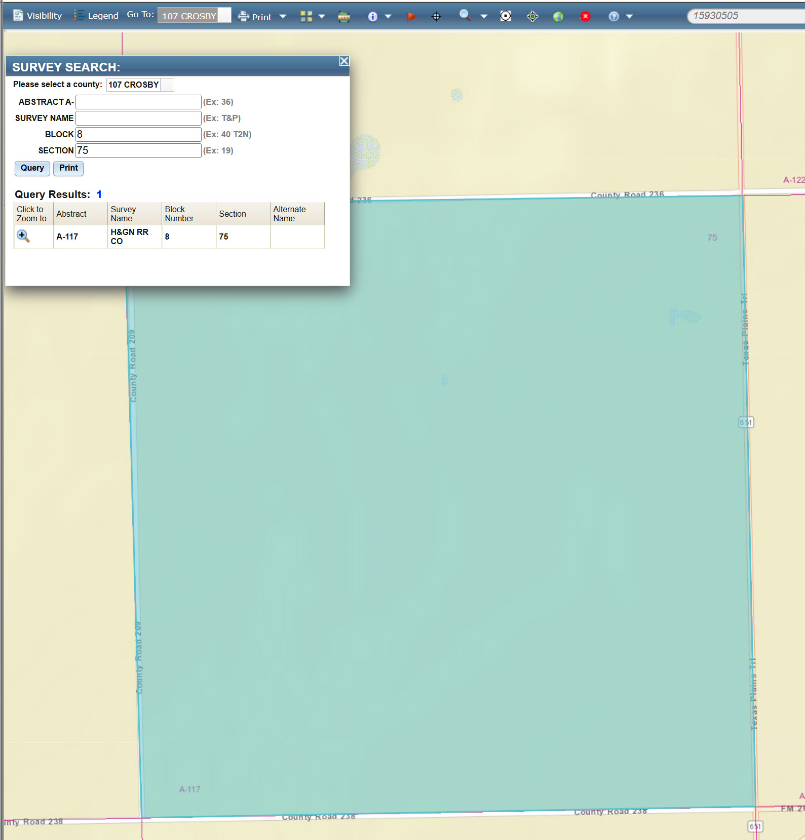
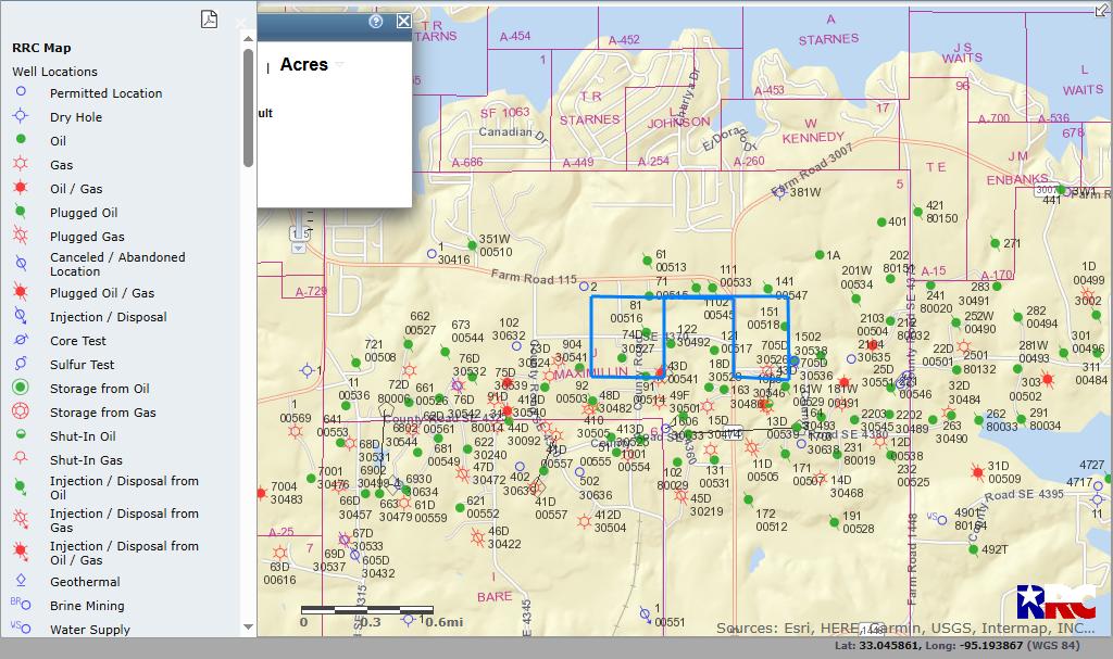
so the way you read this is to first find the section. to do this, you can go to the RRC GIS. click the magnifying glass on the menu (6th icon from the right). choose survey. then a dialog will pop up. you can populate Block with “8” and Section with “75” per your legal description. this will bring up the section. you can see in the attached pic that the survey matches what you shared - so this is the correct section.
E/2 = 1/4 : I’d read this as having a 1/4 mineral interest in the east half of the section. typically sections are 640 acres; but in TX things are sometimes different since most of the state is not on the PLSS system. assuming this is a standard section, you’d have that 1/4 mineral interest in 320 acres.
N/2 SW/4 = 1/8 : I’d read this as having a 1/8 mineral interest in the (here’s where you do something which seems backwards. you read this first as southwest quarter of the section, then the north half of that southwest quarter) southwest quarter and then the north half of that; so that would be 80 acres. so you’d have a 1/8 mineral interest in 80 acres.
on the 2nd pic, I’ve highlighted the legal descriptions you have a mineral interest in so that you can see how the description matches the mapping.
this was actually a good idea that I hadn’t thought of. I took a look; but the information is not such that you can easily drill down to subdivision and lot. I was able to find the Abstract and even the Survey - but going more granular than that was no joy.
Another good thought my friend. I checked the advanced search, and it did have a search for subdivision; but the subdivision mentioned in the deed wasn’t there, so I’m thinking the deeds are so old that the subdivisions no longer exist. no search by lot available.
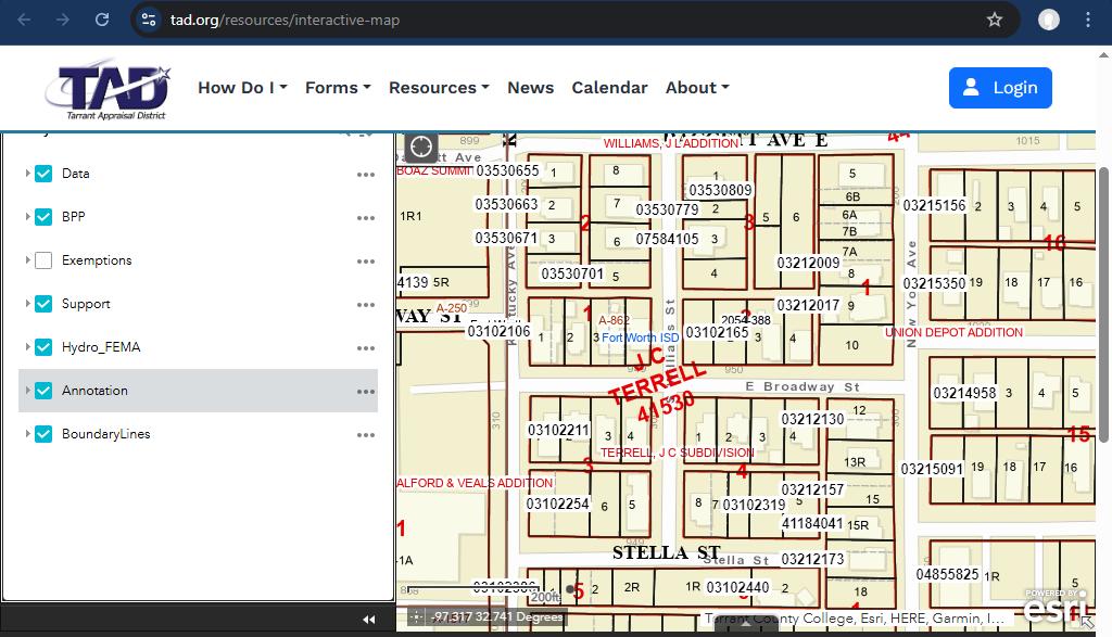
@David_Meinert, the appraisal district maps sometimes help find
subdivisions. See below for a JC Terrell Subdivision in Tarrant County. Also cross references to abstract so nice to see both
on one map. There are apparently a few Maximillian surveys, so not sure which county you are working in.
my bad for not sharing the county in my original post. people are so helpful on this forum, I should have figured someone would actually do a specific look up.
these deeds are in Franklin County, TX; rather than Tarrant County. I did the same drill down exercise on the Franklin County website but had no luck :<(
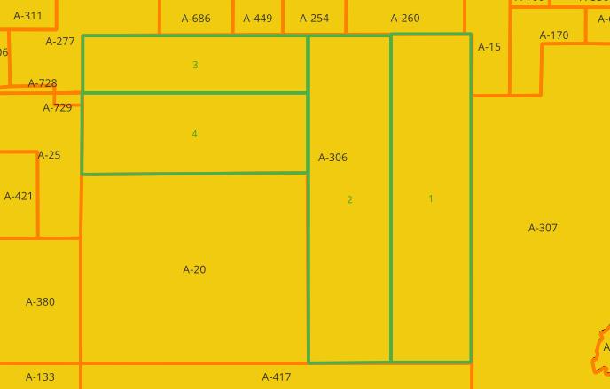
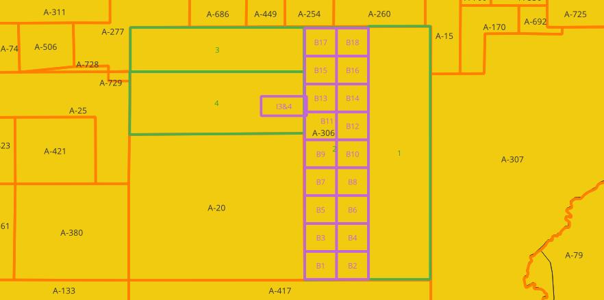
I could not locate the original survey for the blocks 6 & 7
in Tract 4 referenced for the Inman heirs, but their lots
were recorded in the deed reference you gave V48-P411,
Lot 5 of those assignments/subdivisions still survives today
as parcel 4149. Sketch below shows where your interests
overlap the modern parcels:
(Parcel 4150 is most of lot 3 of EE Inman heirs)
(Parcel 3037 is contains JC Terrell Block 14)
This is confirmed by the deed records for those parcels.
Rough sketch on RRC map below, shows about where they are located:
amazing. thank you so much for doing this research. did I simply miss this level of detail on the county website? I’d love to be able to do this myself going forward. if you used some other source - could you share where you obtained this?
again - thank you for this work. incredibly thankful!
@David_Meinert, you are very welcome. The info is from the county deed records. Here is the link to the site which is free to use for document views with registration:
Relevant Deed Record documents were Volume 5, Page 61 (1872 survey) and Volume 59 Page 101 (survey describing partition into 18 blocks) Your deed included Volume 48 Page 411 which is also recorded at Volume 48 Page 536 which describes the 5 Inman lots in Tract 4 of A-306. I agree that it would be nice if deed writers referenced where their Block, Lot and Tract numbers came from. It appears that the 18 blocks survey was in use for some time before it was actually recorded in the county records.