Where to find info for Young County, TX

I just got a little project dumped on me by my wife and brother-in-law. My brother-in-law apparently has some mineral rights which I think are in Young County, TX. The most recent document of any kind that he has is dated 1983, and mentions Mahaney Lease A-1601, and Mahaney #6. It also mentions owner #04004, but that was his sister who passed years ago. Both he, and his sister most likely had equal shares, but I don’t know that for sure.
There are no current leases, or lease offers, that we know of. So the question is, where should I start to find out exactly where these minerals are located, who all of the current owners are, and the status?

Thanks in advance for any assistance

Wayne
You can start by contacting the Young County Clerk to see if they have anything on file.

xeddog…this link is to the approved drilling permit for the Mahaney well # 6 /drilling completed on 10/12/1979/Lease # 17724/API 503-01696…As far as I can tell there is no production coming from this well at this time.

http://webapps2.rrc.texas.gov/EWA/drillingPermitDetailAction.do?methodToCall=searchByUniversalDocNo&universalDocNo=116595&rrcActionMan=H4sIAAAAAAAAAL1Qu27DMAz8mnQUJDk20oGDUaRzkwbNYGRQbEIRIFsGJfcB-ONLuyiQOp0ziXc8HY8clZSgRyUVqAeiuqyTC92-pqaSJ5j5Dzybvo9acFsk_DRR2PC-ysqN5L6GlX7eHksus6lsyHnvOvuC1LoUdwPS14-paAKL1tBiuoTmEJ6M90zkQJgG6g7hFQ3VF6Y2IG-yVHHulmSj6A2Z9s34AeeInCGXmVTFYzGhHM5oXRePLk1m7PYHK73A1_rFWHWvE8Tf1QvojUW6WvHfe6hTtdRNUUGNGpQcMy7WIMec34KJ2993ueY35z4kLV0CAAA

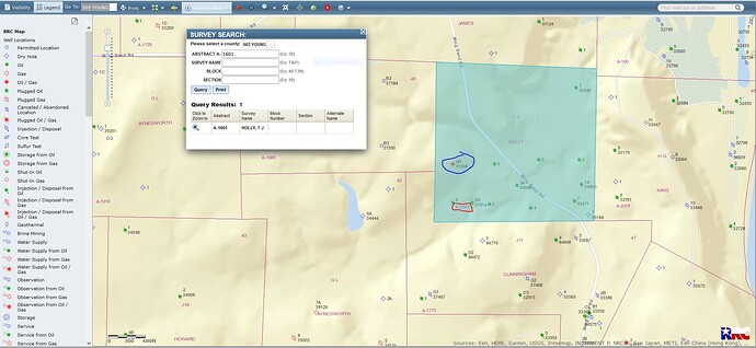
GIS(Geographic Information Survey)map of Young County A-1601/ Mahaney #6 well is circled in blue:

CLICK ON MAP TO ENLARGE

This topic was automatically closed after 90 days. New replies are no longer allowed.